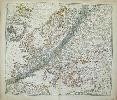
Item details: Europa / Geographica Repraesentatio Europae die 12 Maii 1706 Eclipsatae quae phasium Solis (in 12 digitos divisi) magnitudines quaeris, suis locis apparantes, cum via totalis Umbrae ex multis Illustrium Virorum observantionibus undequaque collectis, per arcos parallelos ope J. Gabr.Doppelmayr curiose ostenduntur ...
£ 450.00
Doppelmayr, J.G. & J.B. Homann:
Europa / Geographica Repraesentatio Europae die 12 Maii 1706 Eclipsatae quae phasium Solis (in 12 digitos divisi) magnitudines quaeris, suis locis apparantes, cum via totalis Umbrae ex multis Illustrium Virorum observantionibus undequaque collectis, per arcos parallelos ope J. Gabr.Doppelmayr curiose ostenduntur ...
Imprint: Nuremberg, c. 1730
Copper engraving, 49.5 x 59 cms, original hand-colour, centrefold split closed, toning at centrefold, blank verso. Homanns map of Europe has been altered to show the path of the eclipse of the sun of May 12 1706, which was visible as a total or partial eclispse across much of Europe. A banner has been added at the top of the map containing explanatory information, including a list of towns where the eclipse was total and where it was partial. The shaded area across Europe shows the centre of the path of the eclipse.