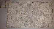
Wood engraving, 55 x 95 cms, dissected into 40 sheets and laid on linen, black and white as issued, one or two small marks in red pencil, folding into original blind-stamped brown cloth covers, dated 1853.
Wylds map was engraved in 1851 for the Great Exhibition and was one of half a dozen maps of London exhibited there. The border is decorated with vignettes of important public buildings and attractions of interest to visitors to the Exhibition - including Wylds own Great Globe (at 40 ft diameter and 60 ft in height the largest ever constructed) in Leicester Square. The plate itself is unchanged: the date on the cover alone identifies the state., Hyde: Printed maps of Victorian London #25 (5).