|
|
|
Imprint: London, [1763]
Binding: Hardback Folio (560 x 390 mm.), modern half calf retaining contemporary marbled paper boards, ornate blind ruling, spine with gilt and blind ruled bands, red calf gilt title label affixed. With 47 engraved double-page mapsheets consisting of a general map of England and Wales by Kitchin, general map of Scotland by James Dorret dated 1761, Bayly of Ireland, and 44 county maps of England and Wales, all in early outline colour, the first map with a stain confined mostly in the margin otherwise generally in good condition.
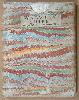
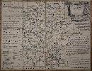
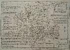
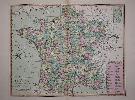
The maps from Emanuel Bowen and Thomas Kitchin’s beautiful 'Large English Atlas' were first issued separately and early issues of the work can be found with varying contents. The final tally of sheets for the atlas was forty-five. The project began at the hands of the publisher John Hinton before he ran into financial difficulties. They are superb clear and concise engravings. In the history of English county atlases it is hard to think of one with finer quality. Wardington praised the book saying that ‘the size of the plate presented the publishers, the engravers and the printers with as formidable a task as any posed by the finest productions of Louis XIV or XV, the best of the Dutch engravings fifty years earlier, or the Ordnance Survey sheets fifty years later’. Hodson (221) provides a thorough account of the complex history of this atlas, which was finally completed and issued with a title-page in c.1762. Tinney died in the spring of 1761, control of his estate being granted to his sister on 14 April 1761. Harold Whitaker reported that an atlas was issued with the imprint of Tinney removed from the title page however no known example has been located. There had been a spate of advertising in May of 1762 which began ‘This Day are published …’ which often marks a new edition. At this time Tinney’s imprint was removed from the maps and to reflect the change of ownership of the atlas the order of some of them was changed. From this Hodson calculates that it was Robert Sayer who purchased Tinney’s shares most likely from his sister. The shareholding was now Thomas Bowles had four shares, Robert Sayer three and John Bowles and Son two. As this work was undertaken to the maps plate numbers were also added.In the Public Advertiser for 16 May 1763, it was announced that two new maps of Scotland and Ireland had been added to the atlas. In October 1763 John Bowles ordered 200 copies of the ‘Title to Bowen’s English atlas, large folio’ to be printed by William Strahan in ‘red and black’ at a cost of £1. 12s. 0d. These were again undated and reflected another change. John Bowles’ son Carington Bowles (1724-93) left the partnership and took over that of his uncle Thomas Bowles (1688-1767). This is believed to have been in 1762 when Thomas was about 74 years old. At first Carington Bowles continued trading under his uncle’s name as can be seen in the new imprint but by 1764 he was using his own. The early owner of this example is Ralph Bates (1764-1813) who was from a prominent Northumbrian family. He became High Sheriff of the County and later Deputy Lieutenant. Provenance: bookplate of Ralph Bates, Milbourne Hall; private English collection; Clive A Burden Ltd. Catalogue 2 (2008) item 28; private foreign collection. Not in Chubb; Hodson 223; not in BL Shirley (2004).
Stock number:10440.
|
|
Imprint: London, John Bowles, and Henry Parker, Carington Bowles, Henry Overton, Thomas Kitchin, Robert Sayer, and John Ryall, c.1764
Edition: First Edition Binding: Hardback Folio (460 x 315 mm.), early nineteenth century half calf, marbled boards, with blind ruling, raised bands with gilt ruled compartments, red calf gilt title label. Typographic title page inserted, printed in red and black and 44 engraved maps all in early outline colour, with nineteenth century? manuscript contents list in the same hand as the manuscript numeration on the maps and the ownership label affixed inside upper cover. Gloucester with small ink stain, Northampton trimmed along the bottom to plate edge, that of South Wales backed on paper to support small tear in to the map, occasional folds to some maps, otherwise in good condition.
An UNRECORDED variant of the FIRST EDITION of the 'Royal English Atlas'. Following the success of the 'Large English Atlas' the publishers Robert Sayer and the Bowles family believed that there would be a market for a more manageable edition. The atlas was �Large� and must have been cumbersome for many. The 'Royal English Atlas' would be printed on �Royal� sized paper and although reduced, is still a good sized folio atlas. The cartographic work had been done; all that would be needed was a fresh set of plates reducing the maps of Emanuel Bowen and Thomas Kitchin. The atlas is known with three variant title pages, all differing in the order in which the owners are named. They are all printed with a common type except the imprints. As Hodson describes �It has already been demonstrated (the Large English Atlas) that by 1760 the order of names on the maps in a jointly-owned atlas was perceived to have commercial importance, and now this notion had been extended to title-pages.� Hodson concludes that as sixteen shares were extant in the atlas by 1825 it is safe to assume the same number were issued at the beginning. Examining the imprints on the maps leads him to believe that Kitchin had four shares and all the remaining partners had two. Of the surviving examples three bear the imprint of Kitchin first, two with Sayer�s and one with Overton�s. This previously unrecorded title page bears that of John Bowles first. It can also be concluded that this example uses an early title page off the press as �New� is misspelt.The atlas however proved to be unsuccessful and only eight examples of the atlas survive today. There could be a number of reasons for this but price is quite probably one. Given the choice of the larger atlas at 3 guineas or this smaller version at 2 guineas most clients opted for the more opulent work. Interestingly at about the same time, 1765, the even smaller 'New English Atlas' by Joseph Ellis appeared on the market and was a runaway success. Hodson cites evidence that the work was thought about as early as 1761. Its exact publication date is not known; no advert having been discovered. We can however glean some idea from the imprints found on the maps and again Hodson goes into this in some detail. He concluded that the engraving began in 1762 and was completed in the middle of 1763. The atlas may have been ready by the end of the year but is given a date of c.1764. Catalogues of Sayer in 1766, John Bowles in 1768 and Sayer and Bennett in 1775 all list the atlas for sale.This is a fine example of one of the great rarities in English county atlases. There are only three other known examples in private hands. The five other recorded examples are: British Library; Bodleian Library; Cambridge University Library (x2) and the Whittaker Library. Provenance: with manuscript ownership label in Latin pasted inside front cover dated '12 Decembris 1850'. Chubb 218; Hodson 233; Shirley BL T.Bow 4a.
Stock number:9730.
|
|
Imprint: London, c.1760
Edition: First Edition 540 x 700 mm. Folded and laid on linen and in attractive marbled board slipcases complete with the printed label of the original seller as published Printed for T. Bowles in St. Pauls Church Yard.
The maps from Emanuel Bowen and Thomas Kitchin�s beautiful 'Large English Atlas' were first issued separately. The project began at the hands of the publisher John Hinton in 1748 before he ran into financial difficulties. They are superb, clear and concise engravings. In the history of English county atlases it is hard to think of one with finer quality. Wardington praised the book saying that �the size of the plate presented the publishers, the engravers and the printers with as formidable a task as any posed by the finest productions of Louis XIV or XV, the best of the Dutch engravings fifty years earlier, or the Ordnance Survey sheets fifty years later�. Demand for folio maps of the English Counties in the early eighteenth century was mostly met by the old maps of Christopher Saxton, John Speed and various other seventeenth century maps. Individual large scale surveys were beginning to be published providing a ready source for accurate information. Hinton clearly saw a market for a fresh set of folio maps. In about 1748 Hinton employed the engravers Emanuel Bowen and Thomas Kitchin to engrave the maps. Hinton had already employed Bowen for the maps in the Universal Magazine from 1747. In May 1749 Hinton announced the publication of the map of Sussex and stated that the balance would be published at the rate of one a month. By 1752 or 1753 he sold his interest and the twenty-eight maps produced to date to the printseller John Tinney. By May 1756 he too felt the financial strains of the project and brought in the most successful printsellers of the time, Thomas Bowles, John Bowles and Son and Robert Sayer. Hodson 221 provides a thorough account of the complex history of this atlas, which was finally completed and issued with a title-page in c.1762. Because of the drawn out nature of the publication earlier states of some of the maps do exist. However the first edition c.1760 should contain maps in state �a� according to Hodson all bearing the names of the four partners. This example is in this first edition state �a�. Harvey & Thorpe 33; Hodson (1984-97) II 221.
Stock number:5299.
|
|
Imprint: London, c.1760
Edition: First Edition Folded and laid on linen and in attractive marbled board slipcases complete with the printed label of the original seller as published Printed for T. Bowles in St. Pauls Church Yard.
The maps from Emanuel Bowen and Thomas Kitchin�s beautiful 'Large English Atlas' were first issued separately. The project began at the hands of the publisher John Hinton in 1748 before he ran into financial difficulties. They are superb, clear and concise engravings. In the history of English county atlases it is hard to think of one with finer quality. Wardington praised the book saying that �the size of the plate presented the publishers, the engravers and the printers with as formidable a task as any posed by the finest productions of Louis XIV or XV, the best of the Dutch engravings fifty years earlier, or the Ordnance Survey sheets fifty years later�. Demand for folio maps of the English Counties in the early eighteenth century was mostly met by the old maps of Christopher Saxton, John Speed and various other seventeenth century maps. Individual large scale surveys were beginning to be published providing a ready source for accurate information. Hinton clearly saw a market for a fresh set of folio maps. In about 1748 Hinton employed the engravers Emanuel Bowen and Thomas Kitchin to engrave the maps. Hinton had already employed Bowen for the maps in the Universal Magazine from 1747. In May 1749 Hinton announced the publication of the map of Sussex and stated that the balance would be published at the rate of one a month. By 1752 or 1753 he sold his interest and the twenty-eight maps produced to date to the printseller John Tinney. By May 1756 he too felt the financial strains of the project and brought in the most successful printsellers of the time, Thomas Bowles, John Bowles and Son and Robert Sayer. Hodson 221 provides a thorough account of the complex history of this atlas, which was finally completed and issued with a title-page in c.1762. Because of the drawn out nature of the publication earlier states of some of the maps do exist. However the first edition c.1760 should contain maps in state �a� according to Hodson all bearing the names of the four partners. This example is in this first edition state �a�. Hodson (1984-97) II 221.
Stock number:5300.
|
|
Imprint: London, 1767
225 x 320 mm., in good condition.
The 'Atlas Anglicanus' was first issued in parts which is exceedingly rare and then as an atlas in 1767 republished in 1777. Emanuel Bowen (fl.1714 d.1767) was a very active engraver whose style is often noted by the extensive use of legends. Emanuel died during the issue of the parts and the work was continued by his son Thomas. However before it was completed Thomas Kitchin would take control of it. This example is in its more usual second state. Skelton-Hodson 254.
Stock number:5708.
|
|
Imprint: London, 1780-c.98
64 x 47 cms,. in fine early wash colour. With small area of slight foxing in the centrefold on the right otherwise on fine thick paper and in excellent condition.
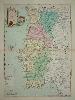
In about 1780 Carington Bowles first published �Bowles�s Universal Atlas�. An example of this edition appears to be in the Library of Congress. It was quite possibly intended to be a smaller and more manageable version of Kitchin�s �General Atlas� first published in 1773. Those maps were often multi sheet and folding making their use difficult. In the Bowles atlas the majority of the maps are single sheet. Bowles appears to have re-issued the atlas with revisions just prior to his death in 1793. He was succeeded by his son Henry Carington Bowles (1763-1830) who shortly after formed a partnership with Samuel Carver. The firm was renamed Bowles and Carver and continued trading at No. 69 St. Pauls Churchyard. Most publications by this firm are rare and �Bowles�s Universal Atlas� is no exception. Undated as before the atlas is usually ascribed the date of 1798 or thereafter based on internal evidence. This fine map of Portugal was first issued in the 1780 edition and here appears in fine full wash colour. Earlier examples are usually in outline colour. An attractive title cartouche appears upper left. "Olhar o Mundo ler o Territorio" Exhibition Catalogue p. 174 illustrating the earlier issue; refer Shirley "Atlases in the British Library" T.Bowl 2a; Tooley's Dictionary of Mapmakers.
Stock number:4240.
|
|
Imprint: London, 1779-c.98
470 x 590 mm., in fine early wash colour, in very good condition.
In about 1780 Carington Bowles first published �Bowles�s Universal Atlas�. An example of this edition appears to be in the Library of Congress. It was quite possibly intended to be a smaller and more manageable version of Kitchin�s �General Atlas� first published in 1773. Those maps were often multi sheet and folding making their use difficult. In the Bowles atlas the majority of the maps are single sheet. Bowles appears to have re-issued the atlas with revisions just prior to his death in 1793. He was succeeded by his son Henry Carington Bowles (1763-1830) who shortly after formed a partnership with Samuel Carver. The firm was renamed Bowles and Carver and continued trading at No. 69 St. Pauls Churchyard. Most publications by this firm are rare and �Bowles�s Universal Atlas� is no exception. Undated as before the atlas is usually ascribed the date of 1798 or thereafter based on internal evidence. Refer Shirley 'Atlases in the British Library' T.Bowl 2a; Tooley's 'Dictionary of Mapmakers'.
Stock number:8845.
|
|
|
Imprint: London, Carington Bowles, At his Map and Print Warehouse, No. 69, St. Paul's Church Yard, 1782
Small octavo, 2 volumes (160 x 100 mm. each), original full green calf, upper board to volume one loose, spines with gilt ruled compartments, red calf gilt title and volume labels affixed, worn. Volume 1, engraved general map of England and Wales, typographic title page, 14 pp. index and distance tables, followed by 50 double page strip road maps, plus 5 pages of text entitled Circuits of the Judges, pp. xv, (1), a-e. Volume 2, typographic title page, followed by 50 double pages of strip road maps, text of the Fairs in England and Wales followed by an advert, pp. (2), 191-243, (2). In good condition.
This is one of several road books of the period with complicated bibliographical histories which with contributions from various researchers, was finally understood during the 1980s and 1990s. It is now known that the first publication of this series of road strips was by Thomas Kitchin in 1771 and entitled Ogilby’s Survey Improved or Kitchin’s New and Instructive Travellers’ Companion. The plates are smaller than those in his re-issue of John Senex’s plates issued in 1767 as the Post-Chaise Companion. They are drawn on a smaller scale and lack compass points. Any titles and notes are placed top and bottom. The intention was to produce an even more comfortable pocket-sized work. Kitchin effectively retired to St. Albans about 1777 and at some point this work was acquired by Carington Bowles. It would seem Bowles was keen to issue the work on acquisition as updates appeared quite rapidly. Two early versions are known, the initial format contained the original 95 plates but was re-titled Bowles’s Post Chaise Companion. Although undated on the title it is given a date of c.1781, only one example is recorded. A ‘Second edition’ was issued for which 2 extra plates were engraved and placed at the end of the second volume and numbered to 194. The last plate in each volume bears the date 4 June 1781. Another ‘Second Edition’ was issued dated 1782 and this offered here, is the most common of the editions with new plates taking the total to 100 which are numbered to 200. It was for sale most likely for several years. The text to this work features an 'Index to the Roads from London and five pages of text entitled Circuits of the Judges in the first volume. The second ends with a large index to the 'Fairs in England and Wales'. Provenance: manuscript inscription on front fee endpaper to volume one of 'Tho. Fenwick' and 'Jas. Davis', the latter repeated on the title page; bookplate in volume two of Thomas Weld Esq., Lulworth Castle; private English collection. Bennett (1996) pp. 67 & 79-80; ESTC T195282; Fordham (1924) p. 35 (not recording Kitchin’s original work); Hodson (1997) III p. 81; Lintot, Roger (1990) ‘Road Map Confusion’, in The Map Collector no. 51 pp. 53-4; Shirley Atlases in the British Library T.Bowl 1a; Smith, David (1991) ‘Road Map Confusion Revisited’, in IMCoS Journal no. 45 pp. 6-11 & Part II issue no. 47 pp. 29-39; Webb (Worms & Baynton-Williams (2011).
Stock number:10183.
|
|
Imprint: London, John Bowles at Mercers Hall in Cheapside, 1728
Binding: Hardback 590 x 1440 mm., early outline colour, five sheets joined (three folio and two side panels), some light toning along two joins with professional restoration, minimal loss, otherwise in good condition.
Thomas Bowles II (c.1695-1767) was not the founder of the family business, his father of the same name was, but he grew the business considerably. London too was growing in prosperity and size and this plan of the city was first published in 1719 to illustrate that fact. At that time there was a fashion for double folio sized maps, a market occupied by atlases produced by Herman Moll, John Senex and George Willdey. It appears that Bowles supplied the maps loose rather than bound together although some composite collections are known to have been put together.This issue is the first to include Cavendish Square and the development of Marylebone. Nearby is the title and both sides contain panels with all the roads keyed to the map which is dissected by a grid. Lower left are the coats of arms of the City of London surrounded by those of the 12 Companies. Lower right is an �Explanation and Use of the Table� which is unusually illustrated with a �map� on how to use it. Two further insets lower centre added in 1723 describe firstly the two key modes of transport in the city, the Watermen and Hackney Coaches. Different routes are listed with their charges shown. The fairs are described as being fixed by Act of Parliament. A total of 700 coaches ply the streets limited to 170 on Sundays. The second inset describes the �Scituation of London� stating that is measures approximately 7.5 by 2 miles in size. It estimates about 5000 �Streets, Lanes & Allies� and about 110,000 houses. The curious estimate of the number of inhabitants at 400,000 is derived from how much food is consumed! Darlington and Howgego in their �Printed Maps of London� describe a state dated 1727 followed by a further date change to 1731. In this latter example the map has been extended eastwards to �include Stepney and the Isle of Dogs�. The example offered here bears not only an unrecorded date of 1728, but an earlier extension eastwards falling short of the Isle of Dogs. It takes in Stepney and the marine district of Wapping. According to Darlington and Howgego this is derived from Gascoigne�s Survey of Stepney in 1701. Closer examination of the 1731 issue in the British Library shows that it bears two half page extension sheets, ours contains just the first. The second was clearly added for the later issue as the city was rapidly expanding eastwards at the time. It is also stated that new buildings were added in Westminster for the 1731 issue but again they are first presented here in 1728.The plan also bears the imprint of John Bowles (c.1701-79) who was originally apprenticed to his elder brother and set up on his own around 1723. He published material frequently in partnership with his brother as here. Provenance: private English collection for 30 years. Darlington & Howgego (1964) no. 63 between states 4 & 5; Tooley�s Dictionary; Worms & Baynton-Williams (2011).
Stock number:8227.
|
|
Imprint: London, 1785
Edition: First Edition Two quarto volumes (190 x 120 mm.), full early marbled calf, gilt panel, rebacked and cornered, blind ruled bands on spine, gilt title and volume number. Original endpapers, with a Carington Bowles advert pasted inside front cover of first volume. With engraved general map of England and Wales in early outline colour, engraved title page, dedication, General Contents, preface 8 pp. and Index to the Direct Roads 29 pp. Volume 1 contains: 186 strip road maps (2 to a page) and then 40 pp. of distance tables. Volume 2: Engraved title page 142 strip road maps (2 to a page) 24 pp. of distance tables a further 30 strip road maps of the Cross Roads, 90 pp. of distance tables, Errata to the verso.
FIRST EDITION. Daniel Paterson (1738-1825) was commissioned in the army in 1765 and served in the Quartermaster General�s department until 1812. He made Assistant Quartermaster General for the last eight years before his retirement. He then became Lieutenant-Governor of Quebec. 'Paterson�s Roads' was first published in 1771 and it proved to be a popular work being published into the nineteenth century. It only contained one general map. In 1785 this rarer work was published by Carington Bowles running to only five editions. It is notable for including some of the first road maps of many parts of Scotland. Provenance: Bookplates of Mr. Brounger pasted inside both volumes; Charles Traylen; private English collection. Carroll (1996) Appendix 15; DNB; ESTC T93554; Fordham (1925b) pp. 344-55; Fordham (1924) p. 36; Shirley (2004) T.Pat 1a; Worms & Baynton-Williams (2011).
Stock number:7290.
|
|
|
Imprint: London, Carington Bowles, At his Map and Print-Warehouse, No. 69 St. Pauls Church Yard, 1785
Edition: First Edition Small quarto (185 x 110 mm.), two volumes, full early marbled calf, gilt panelled, rebacked with raised bands, blind ruled, calf gilt title and volume numbers affixed. Volume 1 with engraved general double-page map of England and Wales in early wash colour, engraved title page, dedication, General Contents, Preface, Index to the Direct Roads, Branch Roads and 186 strip road maps (2 to a page), 187 & 188 blank, pp. x, xxix, (1), 40 [paginated 189-228]; volume 2 with engraved title page 142 strip road maps (2 to a page), branch roads pp. 24 [paginated 143-167], (1), engraved title page to the Cross Roads, a further 30 strip road maps of the Cross Roads beginning on the verso of the title (2 to a page), Cross Roads and Roads in Scotland, Errata to the verso pp. 90, (1) [paginated 31-121].
FIRST EDITION. Daniel Paterson (1738-1825) was born at Duddingston, Edinburgh in 1738. commissioned in the army in 1765 and served in the Quartermaster General�s department until 1812. He made Assistant Quartermaster General for the last eight years before his retirement. He then became Lieutenant-Governor of Quebec until his death in 1825. According to the DNB it seems unlikely that he ever went there. 'Paterson�s Roads' was first published in 1771 and it proved to be a popular work being published into the nineteenth century. It only contained one general map. In 1785, this rarer work was published by Carington Bowles running to only five editions. There are two road strips per page, each individually numbered. It is notable for including some of the first road maps of many parts of Scotland. Paterson made no significant cartographic contribution but did however compile useful works containing much information on the roads. Provenance: bookplate of James Martin pasted inside cover of second volume; private English collection. Coventry 13 Dec 1785' on the final English road strip plates in both volumes; private English collection. Carroll (1996) Appendix 15; ODNB; ESTC T93554; Fordham (1925b) pp. 344-55; Fordham (1924) p. 36; Shirley (2004) T.Pat 1a.
Stock number:9830.
|
|
|
Imprint: London, Carington Bowles, At his Map and Print-Warehouse, No. 69 St. Pauls Church Yard, 1785
Edition: First Edition Small quarto (185 x 115 mm.), two volumes, full early marbled calf, gilt panelled, spine with ornate gilt ruled bands, calf gilt title and volume numbers affixed, light wear. Volume 1 with engraved general double-page map of England and Wales in early wash colour, engraved title page, dedication, General Contents, Preface, Index to the Direct Roads, Cross Roads, 'Scotch' Roads and 186 strip road maps (2 to a page), 187 & 188 blank, pp. x, xxix, (1), 40 [paginated 189-228]; volume 2 with engraved title page 142 strip road maps (2 to a page), branch roads pp. 24 [paginated 143-167], (1), engraved title page to the Cross Roads, a further 30 strip road maps of the Cross Roads beginning on the verso of the title (2 to a page), Cross Roads and Roads in Scotland, Errata to the verso pp. 90, (1) [paginated 31-121], advert pasted on back board of second volume, in good condition.
FIRST EDITION. Daniel Paterson (1738-1825) was born at Duddingston, Edinburgh in 1738. He was commissioned in the army in 1765 and served in the Quartermaster General’s department until 1812. He made Assistant Quartermaster General for the last eight years before his retirement. He then became Lieutenant-Governor of Quebec until his death in 1825. According to the ODNB it seems unlikely that he ever went there. 'Paterson’s Roads' was first published in 1771 and it proved to be a popular work being published into the nineteenth century. It only contained one general map. In 1785, this rarer profusely illustrated work was published by Carington Bowles running to only five editions. There are two road strips per page, each individually numbered. It is notable for including some of the first road maps of many parts of Scotland. Paterson made no significant cartographic contribution but did however compile useful works containing much information on the roads. The general map is divided into two by colour and an engraved dotted line extending from London to Chester. The lower margin of the map states that the roads illustrated to the west of the line are found in the first volume, those to the east are in the second volume. Provenance: bookplate of Arthur Hugh Smith Barry of Marbury Hall pasted on first free endpaper opposing similar shelf number plate inside covers; of second volume; private English collection. Carroll (1996) Appendix 15; ESTC T93554; Fordham (1924) p. 36; Fordham (1925b) pp. 344-55; ODNB; Shirley (2004) T.Pat 1a.
Stock number:10191.
|
|
|
Imprint: London, Bowles & Carver, At their Map and Print-Warehouse, No. 69 St. Paul's Church Yard, 1807
Small quarto (185 x 110 mm.), two volumes, full original marbled calf, gilt panelled, spine with ornate blind ruled compartments, with gilt calf title and volume labels. Volume 1 with engraved general map of England and Wales, engraved title page, engraved dedication, General Contents, preface 8 pp. and Index to the Direct Roads, 340 engraved road strip maps (2 to a page), Direct Roads of a lesser notes paginated 341-403, pp. xxxv, [62], blank. Volume 2: Engraved title page, 46 [cross] road strip maps (2 to a page), distance tables, various other tables, an index and a page of additions paginated 450-634. Slight wear to the binding but generally in very good condition.
Daniel Paterson (1738-1825) was born at Duddingston, Edinburgh in 1738. He was commissioned in the army in 1765 and served in the Quartermaster General’s department until 1812. He made Assistant Quartermaster General for the last eight years before his retirement. He then became Lieutenant-Governor of Quebec until his death in 1825. According to the ODNB it seems unlikely that he ever went there. 'Paterson’s Roads' was first published in 1771 and it proved to be a popular work being published into the nineteenth century. It only contained one general map. In 1785, this rarer profusely illustrated work was published by Carington Bowles (1724-93) running to only five editions. There are two road strips per page, each individually numbered. It is notable for including some of the first road maps of many parts of Scotland. Paterson made no significant cartographic contribution but did however compile useful works containing much information on the roads. This 'Second Edition Improved' of 1807 is in fact the final issue. It was published by Carington Bowles’ successors, Henry Carington Bowles (his son) in partnership with Samuel Carver. In this issue there is a change of format. In this work the direct roads are all consecutive in the first volume. The crossroads are in the second volume. All plates and text pages are numbered consecutively throughout the two volumes. The general map has had the engraved dividing line marking the two volumes erased. New statements above and below the map allude to the location of specific roads. Provenance: private English collection. Carroll (1996) Appendix 15; Fordham (1924) p. 37; Fordham (1925b) 'Paterson’s Roads' pp. 344-55; ODNB.
Stock number:10192.
|
|
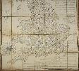
Imprint: London, c.1730
360 x 220 mm., in good condition.
This is at first glance an index of contents to the 'World Described' by Herman Moll, his double folio world atlas. From about 1730 examples were sold by John Bowles (1701-79), one of the most active of the Bowles family of map and print sellers which dominated much of the eighteenth century. Although this is a contents list for the atlas it bears below a list of other publications some of which have no connection to Herman Moll. The list is therefore a John Bowles production. It offers 'A Sett of fifty new and correct Maps of England and Wales' first published in 1724, 'A Sett of Thirty-six new and correct Maps of Scotland' first published in 1725, 'A Sett of Twenty new and correct Maps of Ireland' first published in 1728, the 'Geographia Antiqua' first published in 1721, the 'Britannia Depicta' from 1720 and lastly the 'Atlas Minor' first published in 1729. Worms and Baynton-Williams cite that Bowles however moved to the Black Horse in Cornhill in 1730. These broadside sheets were issued for distribution and as such have an appalling survival rate unless as is likely here it was pasted inside an atlas at some time. Worms & Baynton-Williams (2011).
Stock number:8672.
|
|
Imprint: London, 1816
245 x 330 mm., a fine early coloured aquatint engraving in good condition.
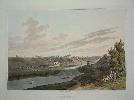
A fine aquatint view of Smolensk to the west of Moscow from R. Bowyer's 'Illustrated Record of Important Events in the Annals of Europe'. Tooley 'English Books with Coloured Plates 1790-1860' no. 97 no.3.
Stock number:4462.
|
|
|
Imprint: London, J Boydell Engraver at the Unicorn the corner of Queen Street Cheapside, 1752
260 x 410 mm., with faint crease at the bottom, otherwise in good condition.
The water works were built in 1723 to supply fresh water to London. They were located on the banks of the River Thames at Chelsea at the north end of present-day Chelsea Bridge. Originally constructed using a water wheel but here the pumping engine seen is most likely a Newcomen steam engine. In 1829 the world’s first water purification system was installed here. In 1869 the site became part of the route of the railway line into Victoria.John Boydell (1719-1804) was born in Dorrington, Shropshire in 1719 and began his career as a land surveyor just like his father Joseph before him. He then began a career as an engraver before moving into the business of printing and publishing. He famously purchased the plates of William Hogarth from his widow. Large oblong views of London were particularly popular in London during the middle and latter portion of the eighteenth century. More than anyone it was Boydell who was responsible for making the print trade in London more export orientated than import. Many of his views were later collected into ‘A Collection of Views of England and Wales’ first published in 1770. Adams 47.5, Cohen (1985) (1985). ‘The Thames 1580-1980 A General Bibliography’ p. 86-7; Worms and Baynton-Williams.
Stock number:10433.
|
|
Imprint: Manchester, 14 January 1839
Binding: Hardback 1620 x 1025 mm., early outline colour, dissected into segments and laid on linen, with marbled endpapers, light stain to left side, some off setting to cartouche. Folds into original publisher's full maroon calf gilt ruled and ornate blind panelled boards, rebacked preserving original spine with gilt title. Bound with 'Tables of the Gradients to Bradshaw's Map of the Railways of Great Britain, Containing Particulars of Lengths, Levels and Gradients of all the Principal Railways in the Kingdom', 14 January 1839, pp. 32, with several tables.
THE FIRST RAILWAY MAP. The name George Bradshaw (1801-53) is synonymous with the British Railways. He was the author and publisher of the railway guides which were such an important part of Victorian travel. 'Bradshaw, whose name was to become synonymous with railway timetables, published his first guide in 1830 with the opening of the Liverpool-Manchester Line and his first timetable in 1839, the same year as this, the first railway map' (Wardington). Apprenticed to an engraver in Manchester, Bradshaw shadowed the industrial revolution and began by publishing maps of the Canal networks in 1829. These were on a very large scale with great detail. In the introduction to this work Bradshaw states 'It would be superfluous to expatriate on the vast utility of a correct map of the Railways of this Kingdom. The want of such a work has been long felt and acknowledged'. The map depicts extant lines in red, those before Parliament in blue and those in yellow proposed. An inset features those in the region of London. This network is laid on the existing road network; the whole is engraved by John Dower at the scale of 10 miles to an inch. In the margins may be found thirty-three fascinating sections of the main railway lines drawn to scale displaying length and elevation. Particular detail is given to identifying the gradients of the railways which was a particular hazard to early railways. In 1830 the network of passenger railways stood at barely 100 miles, by the end of the decade when this map was published the figure stood above 2000 miles. It is not generally known which map bears the accolade of displaying the first railroad, after all the earliest were for purely mining purposes. Indeed, there are earlier maps which display passenger railways. However, Bradshaw�s map of 1839, as Shirley states, is 'undoubtedly the first large scale map to treat railways as the primary subject in terms of content and presentation. The first state of his map is now rare, and even later editions with the overprinting of the routes of newly construed lines are relatively uncommon'. Provenance: private English collection. James (1983); Shirley (1987); Wardington sale, Sotheby�s 18 October 2005 lot 69.
Stock number:9486.
|
|
Imprint: Cologne, 1590
335 x 480 mm., in fine wash colour, with a small worm hole and some age toning.
Early detailed town plan of this Italian port. Ex 'Civitates Orbis Terrarum'. Koeman B & H 1 no. 46.
Stock number:3026.
|
|
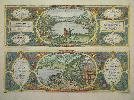
Imprint: Cologne, 1581
325 x 470 mm., in good modern colour, good condition.
Two decorated views near the town of Cumae, near Naples, Italy. The upper view depicts the grotto of Cumaean Sibyl with two figures in the foreground discussing the scene. These are the cartographer Abraham Ortelius and the engraver George Hoefnagel. According to the inscription nearby they are doubting that Lake Averno was the reputed entrance to Hades according to Virgil's Aeneid. The lower view shows the Cave of Dogs so named because of the poisonous sulphur fumes that emanated from it. The 'Civitates Orbis Terrarum' was compiled by George Braun (1541-1622) the Canon of Cologne Cathedral. Braun produced a total of over 500 city views and maps published in six parts between 1572 and 1617. Most of the engraving was the work of Simon Novellanus and Frans Hogenberg (1535-1590), many after drawings by Hoefnagel. Published in the third volume with Latin text in 1581. Koeman II B & H 3 no. 57.
Stock number:4708.
|
|
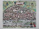
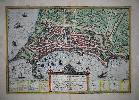
Imprint: Cologne, 1581-[82]
360 x 390 mm., fine recent wash colour, with German text to the verso, in good condition.
An attractive early birds-eye view of the city of Orleans on the River Loire in France in fine wash colour typical of the period. The 'Civitates Orbis Terrarum' was compiled by George Braun (1541-1622) the Canon of Cologne Cathedral. Braun produced a total of over 500 city views and maps published in six parts between 1572 and 1617. Most of the engraving was the work of Simon Novellanus and Frans Hogenberg (1535-1590), many after drawings by George Hoefnagel. Published in the third volume first issued in 1581, the German edition following the ensuing year. Orleans is a city with a rich history. At the time of its publication the city was enjoying the prosperity which the University and the income from the bridge across the river brought in. Koeman II B & H 3 no. 6.
Stock number:8330.
|
|