|
|
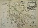
Imprint: London, 1753
520 x 710 mm., early outline colour, three very minor repairs to small tears on the upper edge professionally repaired, otherwise in good condition.
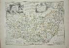
VERY RARE EARLY SEPARATELY PUBLISHED STATE. The maps from Emanuel Bowen and Thomas Kitchinâs beautiful 'Large English Atlas' were first issued separately. The project began at the hands of the publisher John Hinton in 1748 before he ran into financial difficulties. They are superb, clear and concise engravings. In the history of English county atlases it is hard to think of one with finer quality. Wardington praised the book saying that âthe size of the plate presented the publishers, the engravers and the printers with as formidable a task as any posed by the finest productions of Louis XIV or XV, the best of the Dutch engravings fifty years earlier, or the Ordnance Survey sheets fifty years laterâ. Demand for folio maps of the English Counties in the early eighteenth century was mostly met by the old maps of Christopher Saxton, John Speed and various other seventeenth century maps. Individual large scale surveys were beginning to be published providing a ready source for accurate information. In the case of Cornwall it was based on the exceedingly rare Joel Gascoyne of 1699. Hinton clearly saw a market for a fresh set of folio maps. In about 1748 Hinton employed the engravers Emanuel Bowen and Thomas Kitchin to engrave the maps. Hinton had already employed Bowen for the maps in the 'Universal Magazine' from 1747. In May 1749 Hinton announced the publication of the map of Sussex and stated that the balance would be published at the rate of one a month. By 1752 or 1753 he sold his interest and the twenty-eight maps produced to date to the printseller John Tinney. By May 1756 he too felt the financial strains of the project and brought in the most successful printseller's of the time, Thomas Bowles, John Bowles and Son and Robert Sayer. Hodson 221 provides a thorough account of the complex history of this atlas, which was finally completed and issued with a title-page in c.1762. Because of the long publication history of the atlas the maps all appear with several different imprints. That of Suffolk is found in nine states. This example is in Hodson's state T, the second state, reflecting the sale to John Tinney. Hodson (1984-97) II 221 & p. 135; Worms & Baynton-Williams (2011).
Stock number:2607.
|
|
Imprint: London, c.1764.
Edition: First Edition 42 x 51 cms., in early outline colour. A little foxing confined to the lower right corner in the margin only.
Following the success of the earlier published 'Large English Atlas', Bowen and Kitchin undertook a smaller version entitled the 'Royal English Atlas'. It was not a commercial success and as such is much rarer than its predecessor. Indeed the first edition is only known in 6 examples. The imprint below the map indicates that this map is a first state example as only issued in the first edition. It is a wonderful collection of cartographers of the day including the names of Henry Overton, John Bowles, Carington Bowles, John Ryall, Robert Sayer and Thomas Kitchin. Provenance ex Phillips auction 20 September 1984 lot 408. Hodson 233 p. 23 state 1; Shirley BL T.Bow-4a.
Stock number:3897.
|
|
Imprint: London, c.1763-[79]
Edition: First Edition 42 x 51 cms., early outline colour, with lower centre fold split, restored
Following the success of the earlier published 'Large English Atlas', Bowen and Kitchin undertook a smaller version entitled the 'Royal English Atlas'. It was not a commercial success and as such is much rarer than its predecessor. Indeed the first edition is only known in 6 examples. The imprint below the map was altered to reflect the changes in ownership with Robert Sayer and John Bennett's names being included. Hodson 42.2; Skelton - Hodson 234.
Stock number:3478.
|
|
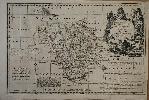
Imprint: London, John Tinney, 1753
70 x 53 cms., early outline colour. In excellent condition with large margins
From 'The Large English Atlas'. Thomas Kitchin was one of the most notable English cartographers of the eighteenth century. He was both an engraver and publisher of considerable reputation who was made Hydrographer to King George III. He worked with many of his contemporaries on various projects. 'The Large English Atlas' was the greatest English county atlas of the eighteenth century and it had a troubled and complicated beginning. The ownership changed many times and the imprints on the maps changed accordingly. This is a fine example of the second although still pre-atlas state by John Tinney with his imprint. Hodson 221 p. 133.
Stock number:4283.
|
|
Imprint: London, J. Bowles, C. Bowles & R. Sayer, c.1764
520 x 700 mm., early outline colour, split centrefold and small margin tear repaired otherwise in good condition.
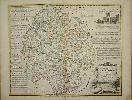
The maps from Emanuel Bowen and Thomas Kitchins beautiful 'Large English Atlas' were first sold separately and early issues of the work can be found with varying contents. The project began at the hands of the publisher John Hinton before he ran into financial difficulties. They are superb clear and concise engravings. In the history of English county atlases it is hard to think of one with finer quality. Wardington praised the book saying that the size of the plate presented the publishers, the engravers and the printers with as formidable a task as any posed by the finest productions of Louis XIV or XV, the best of the Dutch engravings fifty years earlier, or the Ordnance Survey sheets fifty years later. Hodson 221 provides a thorough account of the complex history of this atlas, which was finally completed and issued with a title-page in c.1762. This example of the map of Herefordshire is in its fourth state of five. Not in Chubb; Hodson 223, p. 127 & p. 131 state e; Smith Hereford pp. 83-4.
Stock number:5491.
|
|
Imprint: London, J. Bowles, R. Sayer & C. Bowles, c.1764
700 x 530 mm., in early outline colour, with mild paper crease, a good strong impression
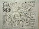
The maps from Emanuel Bowen and Thomas Kitchins beautiful 'Large English Atlas' were first sold separately and early issues of the work can be found with varying contents. The project began at the hands of the publisher John Hinton before he ran into financial difficulties. They are superb clear and concise engravings. In the history of English county atlases it is hard to think of one with finer quality. Wardington praised the book saying that the size of the plate presented the publishers, the engravers and the printers with as formidable a task as any posed by the finest productions of Louis XIV or XV, the best of the Dutch engravings fifty years earlier, or the Ordnance Survey sheets fifty years later. Hodson 221 provides a thorough account of the complex history of this atlas, which was finally completed and issued with a title-page in c.1762. This example of the map of Northamptonshire is in its seventh state of nine. Not in Chubb; Hodson 223, p. 127 & p. 133 state f.
Stock number:5493.
|
|
Imprint: London, Robert Sayer and Carington Bowles, c.1764
530 x 700 mm., in fine early outline colour, lower centrefold split otherwise in good condition.
The maps from Emanuel Bowen and Thomas Kitchins beautiful 'Large English Atlas' were first sold separately and early issues of the work can be found with varying contents. The project began at the hands of the publisher John Hinton before he ran into financial difficulties. They are superb clear and concise engravings. In the history of English county atlases it is hard to think of one with finer quality. Wardington praised the book saying that the size of the plate presented the publishers, the engravers and the printers with as formidable a task as any posed by the finest productions of Louis XIV or XV, the best of the Dutch engravings fifty years earlier, or the Ordnance Survey sheets fifty years later. Hodson 221 provides a thorough account of the complex history of this atlas, which was finally completed and issued with a title-page in c.1762. This example of the map of Worcestershire is in its fourth state of five. Not in Chubb; Hodson 223, p. 127 & p. 137 state g.
Stock number:5723.
|
|
Imprint: London, Carington Bowles and Robert Sayer, c.1765
355 x 525 mm., early outline colour, with margin extension at the bottom as expected, otherwise in good condition.
From Emanuel Bowen and Thomas Kitchen's landmark 'Large English Atlas', the finest English county atlas of the eighteenth century. Hodson 221.
Stock number:7493.
|
|
|
Imprint: London, Carington Bowles, John Bowles and Robert Sayer, 1750-[c.62]
530 x 650 mm., early outline colour, in good condition.
The maps from Emanuel Bowen and Thomas Kitchins beautiful 'Large English Atlas' were first sold separately and early issues of the work can be found with varying contents. The project began at the hands of the publisher John Hinton before he ran into financial difficulties. They are superb clear and concise engravings. In the history of English county atlases it is hard to think of one with finer quality. Wardington praised the book saying that the size of the plate presented the publishers, the engravers and the printers with as formidable a task as any posed by the finest productions of Louis XIV or XV, the best of the Dutch engravings fifty years earlier, or the Ordnance Survey sheets fifty years later. Hodson 221 provides a thorough account of the complex history of this atlas, which was finally completed and issued with a title-page in c.1762. This example of the map of the East Riding of Yorkshire was issued following the death of John Bowles in the summer of 1779. Here though Robert Wilkinson's imprint was never added. He appears to have acquired the stock quickly as by December he had taken delivery of 150 printed 'Titles to Large English Atlas, Broadside'. Chubb 199; Hodson 227 & p. 137 state e; Rawnsley 25.
Stock number:9746.
|
|
|
Imprint: London, Carington Bowles, R. Wilkinson & Robert Sayer, c.1760
520 x 700 mm., early outline colour, some light offsetting otherwise in good condition.
The maps from Emanuel Bowen and Thomas Kitchins beautiful 'Large English Atlas' were first sold separately and early issues of the work can be found with varying contents. The project began at the hands of the publisher John Hinton before he ran into financial difficulties. They are superb clear and concise engravings. In the history of English county atlases it is hard to think of one with finer quality. Wardington praised the book saying that the size of the plate presented the publishers, the engravers and the printers with as formidable a task as any posed by the finest productions of Louis XIV or XV, the best of the Dutch engravings fifty years earlier, or the Ordnance Survey sheets fifty years later. Hodson 221 provides a thorough account of the complex history of this atlas, which was finally completed and issued with a title-page in c.1762. This example of the map of the West Riding of Yorkshire was issued following the death of John Bowles in the summer of 1779. Robert Wilkinson appears to have acquired the stock quickly as by December he had taken delivery of 150 printed 'Titles to Large English Atlas, Broadside'. Chubb 199; Hodson 227 & p. 138 state h; Rawnsley 25.
Stock number:9748.
|
|
|
Imprint: London, John Tinney, 1754
700 x 530 mm., uncut, early outline colour, light crease to left corners, some light foxing, otherwise in good condition.
An example of the FIRST STATE published by John Tinney in 1754. The maps from Emanuel Bowen and Thomas Kitchins beautiful 'Large English Atlas' were first issued separately. The project began at the hands of the publisher John Hinton in 1748 before he ran into financial difficulties. They are superb, clear and concise engravings. In the history of English county atlases it is hard to think of one with finer quality. Wardington praised the book saying that the size of the plate presented the publishers, the engravers and the printers with as formidable a task as any posed by the finest productions of Louis XIV or XV, the best of the Dutch engravings fifty years earlier, or the Ordnance Survey sheets fifty years later. Demand for folio maps of the English Counties in the early eighteenth century was mostly met by the old maps of Christopher Saxton, John Speed and various other seventeenth century maps. Individual large scale surveys were beginning to be published providing a ready source for accurate information. In the case of Cornwall it was based on the exceedingly rare Joel Gascoyne of 1699. Hinton clearly saw a market for a fresh set of folio maps. In about 1748 Hinton employed the engravers Emanuel Bowen and Thomas Kitchin to engrave the maps. Hinton had already employed Bowen for the maps in the 'Universal Magazine' from 1747. In May 1749 Hinton announced the publication of the map of Sussex and stated that the balance would be published at the rate of one a month. By 1752 or 1753 he sold his interest and the twenty-eight maps produced to date to the printseller John Tinney. By May 1756 he too felt the financial strains of the project and brought in the most successful printseller's of the time, Thomas Bowles, John Bowles and Son and Robert Sayer. Hodson 221 provides a thorough account of the complex history of this atlas, which was finally completed and issued with a title-page in c.1762. Because of the long publication history of the atlas the maps all appear with several different imprints. With inset views of Carmarthen and Cardiff. This map is found in five states, this example is in Hodson's state T, the first, issued before the work was completed. Booth (1977) p. 86; Hodson (1984-97) II 221 & p. 138; Worms & Baynton-Williams (2011).
Stock number:10059.
|
|
|
Imprint: London, John Tinney at the Golden Lion in Fleet Street, 1754
700 x 530 mm., uncut, early outline colour, light crease to left corners, some light foxing, otherwise in good condition.
An example of the FIRST STATE published by John Tinney in 1754. The maps from Emanuel Bowen and Thomas Kitchins beautiful 'Large English Atlas' were first issued separately. The project began at the hands of the publisher John Hinton in 1748 before he ran into financial difficulties. They are superb, clear and concise engravings. In the history of English county atlases it is hard to think of one with finer quality. Wardington praised the book saying that the size of the plate presented the publishers, the engravers and the printers with as formidable a task as any posed by the finest productions of Louis XIV or XV, the best of the Dutch engravings fifty years earlier, or the Ordnance Survey sheets fifty years later. Demand for folio maps of the English Counties in the early eighteenth century was mostly met by the old maps of Christopher Saxton, John Speed and various other seventeenth century maps. Individual large scale surveys were beginning to be published providing a ready source for accurate information. In the case of Cornwall it was based on the exceedingly rare Joel Gascoyne of 1699. Hinton clearly saw a market for a fresh set of folio maps. In about 1748 Hinton employed the engravers Emanuel Bowen and Thomas Kitchin to engrave the maps. Hinton had already employed Bowen for the maps in the 'Universal Magazine' from 1747. In May 1749 Hinton announced the publication of the map of Sussex and stated that the balance would be published at the rate of one a month. By 1752 or 1753 he sold his interest and the twenty-eight maps produced to date to the printseller John Tinney. By May 1756 he too felt the financial strains of the project and brought in the most successful printseller's of the time, Thomas Bowles, John Bowles and Son and Robert Sayer. Hodson 221 provides a thorough account of the complex history of this atlas, which was finally completed and issued with a title-page in c.1762. Because of the long publication history of the atlas the maps all appear with several different imprints. With inset views of Haverford West. This map is found in seven states, this example is in Hodson's state T, the first, issued before the work was completed. Booth (1977) p. 86; Hodson (1984-97) II 221 & p. 138; Worms & Baynton-Williams (2011).
Stock number:10060.
|
|
|
Imprint: London, R. Sayer & Carington Bowles, 1767
Edition: First Edition 530 x 700 mm., early outline colour, in good condition.
The maps from Emanuel Bowen and Thomas Kitchinâs beautiful 'Large English Atlas' were first issued separately. The project began at the hands of the publisher John Hinton in 1748 before he ran into financial difficulties. They are superb, clear and concise engravings. In the history of English county atlases it is hard to think of one with finer quality. Wardington praised the book saying that âthe size of the plate presented the publishers, the engravers and the printers with as formidable a task as any posed by the finest productions of Louis XIV or XV, the best of the Dutch engravings fifty years earlier, or the Ordnance Survey sheets fifty years laterâ. Demand for folio maps of the English Counties in the early eighteenth century was mostly met by the old maps of Christopher Saxton, John Speed and various other seventeenth century maps. Individual large scale surveys were beginning to be published providing a ready source for accurate information. Hinton clearly saw a market for a fresh set of folio maps. In about 1748 Hinton employed the engravers Emanuel Bowen and Thomas Kitchin to engrave the maps. Hinton had already employed Bowen for the maps in the Universal Magazine from 1747. In May 1749 Hinton announced the publication of the map of Sussex and stated that the balance would be published at the rate of one a month. By 1752 or 1753 he sold his interest and the twenty-eight maps produced to date to the printseller John Tinney. By May 1756 he too felt the financial strains of the project and brought in the most successful printsellers of the time, Thomas Bowles, John Bowles and Son and Robert Sayer. Hodson 221 provides a thorough account of the complex history of this atlas, which was finally completed and issued with a title-page in c.1762. Because of the drawn out nature of the publication earlier states of some of the maps do exist. However the first edition c.1760 should contain maps in state âaâ according to Hodson all bearing the names of the four partners. This example is in Hodson's fourth state 'g' and most likely issued before publication of the atlas. Provenance: Clive A. Burden Ltd. Baum p. 24; Deadman & Brooks 'Leicestershire' p. 76; Deadman & Brooks 'Rutland' p. 78; Hodson (1984-97) II 221.
Stock number:10404.
|
|
|
Imprint: London, J. Tinney, R. Sayer, T. Bowles & J. Bowles & Son, 1756
Edition: First Edition 540 x 700 mm., folded and laid on linen and in attractive marbled board slipcase, complete with the printed label of the original seller as published 'Printed for T. Bowles in St. Pauls Church Yard', early outline colour, a couple of small wormholes, otherwise in good condition.
The maps from Emanuel Bowen and Thomas Kitchinâs beautiful 'Large English Atlas' were first issued separately. The project began at the hands of the publisher John Hinton in 1748 before he ran into financial difficulties. They are superb, clear and concise engravings. In the history of English county atlases it is hard to think of one with finer quality. Wardington praised the book saying that âthe size of the plate presented the publishers, the engravers and the printers with as formidable a task as any posed by the finest productions of Louis XIV or XV, the best of the Dutch engravings fifty years earlier, or the Ordnance Survey sheets fifty years laterâ. Demand for folio maps of the English Counties in the early eighteenth century was mostly met by the old maps of Christopher Saxton, John Speed and various other seventeenth century maps. Individual large scale surveys were beginning to be published providing a ready source for accurate information. Hinton clearly saw a market for a fresh set of folio maps. In about 1748 Hinton employed the engravers Emanuel Bowen and Thomas Kitchin to engrave the maps. Hinton had already employed Bowen for the maps in the Universal Magazine from 1747. In May 1749 Hinton announced the publication of the map of Sussex and stated that the balance would be published at the rate of one a month. By 1752 or 1753 he sold his interest and the twenty-eight maps produced to date to the printseller John Tinney. By May 1756 he too felt the financial strains of the project and brought in the most successful printsellers of the time, Thomas Bowles, John Bowles and Son and Robert Sayer. Hodson 221 provides a thorough account of the complex history of this atlas, which was finally completed and issued with a title-page in c.1762. Because of the drawn out nature of the publication earlier states of some of the maps do exist. However the first edition c.1760 should contain maps in state âaâ according to Hodson all bearing the names of the four partners. This example is in the first edition, state âaâ and most likely issued before publication of the atlas. Baum p. 24; Deadman & Brooks 'Leicestershire' p. 76; Deadman & Brooks 'Rutland' p. 78; Hodson (1984-97) II 221.
Stock number:10405.
|
|
|
Imprint: London, c.1760
540 x 700 mm., folded and laid on linen and in contemporary publisher's marbled paper slipcase open to the side, complete with the printed label of the original seller 'Thomas Jefferys Engraver ...', early outline colour, foxed and evenly toned, with trimmed to the neatline losing the imprint below, otherwise in good condition.
The maps from Emanuel Bowen and Thomas Kitchinâs beautiful 'Large English Atlas' were first issued separately. The project began at the hands of the publisher John Hinton in 1748 before he ran into financial difficulties. They are superb, clear and concise engravings. In the history of English county atlases it is hard to think of one with finer quality. Wardington praised the book saying that âthe size of the plate presented the publishers, the engravers and the printers with as formidable a task as any posed by the finest productions of Louis XIV or XV, the best of the Dutch engravings fifty years earlier, or the Ordnance Survey sheets fifty years laterâ. Demand for folio maps of the English Counties in the early eighteenth century was mostly met by the old maps of Christopher Saxton, John Speed and various other seventeenth century maps. Individual large scale surveys were beginning to be published providing a ready source for accurate information. Hinton clearly saw a market for a fresh set of folio maps. In about 1748 Hinton employed the engravers Emanuel Bowen and Thomas Kitchin to engrave the maps. Hinton had already employed Bowen for the maps in the Universal Magazine from 1747. In May 1749 Hinton announced the publication of the map of Sussex and stated that the balance would be published at the rate of one a month. By 1752 or 1753 he sold his interest and the twenty-eight maps produced to date to the printseller John Tinney. By May 1756 he too felt the financial strains of the project and brought in the most successful printsellers of the time, Thomas Bowles, John Bowles and Son and Robert Sayer. Hodson 221 provides a thorough account of the complex history of this atlas, which was finally completed and issued with a title-page in c.1762. Because of the drawn out nature of the publication earlier states of some of the maps do exist. This example is of particular interest due to the seller's label on the slipcase. It states that Thomas Jefferys 'Sells great Variety of Maps and Prints English and Foreign by the most Celebrated Masters'. Baum p. 24; Deadman & Brooks 'Leicestershire' p. 76; Deadman & Brooks 'Rutland' p. 78; Hodson (1984-97) II 221.
Stock number:10413.
|
|
|
Imprint: London, c.1764
Edition: First Edition 420 x 500 mm., in early outline colour, with two small areas of repair, otherwise in good condition.
EXCEEDINGLY RARE FIRST STATE. Following the success of the earlier published 'Large English Atlas', Emanuel Bowen and Thomas Kitchin undertook a 'smaller' folio version entitled the 'Royal English Atlas'. It was not a commercial success and as such is much rarer than its predecessor. Indeed the first edition is only known in 6 examples. The imprint below the map indicates that this example is in the first state as only issued in the first edition. The imprint bears a wonderful collection of the cartographers of the day 'Printed for T[homas]. Bowles in St. Pauls Church Yard, J[ohn] Bowles & Son. and Mess. [Elizabeth] Bakewell & [Henry] Parker in Cornhill, H[enry] Overton without Newgate, T[homas] Kitchin on Holborn Hill, R[obert] Sayer & J[ohn] Ryall & in Fleet Street. A good example of an extremely rare map KNOWN IN ONLY 6 EXAMPLES. Hodson 233 p. 25 state 1; Shirley BL T.Bow-4a; Worms & Baynton-Williams (2011).
Stock number:10351.
|
|
Imprint: London, 1767-68
Edition: First Edition Binding: Hardback Folio (380 x 255 mm.), full modern calf, with blind ruled centre panel including ornate floral corner designs, gilt ruled edges, ribbed spine with gilt ruled compartments, each with blind ornate stamp, gilt title label. With engraved title page and 45 copper engraved maps in early outline colour, part of the right margin of title torn away and repaired, one letter of the title lost, light staining to title, first general map with some very light repair in the margin, light brown stain to Northamptonshire, the final map of Yorkshire with extended margin top and right, otherwise in good condition.
An example of the FIRST EDITION, FIRST ISSUE. This atlas was first published in 1767 as the 'Atlas Anglicanus' in response to Ellis popular English Atlas first published in 1765. The 'Atlas Anglicanus' like many projects at the time began life by being published in monthly numbers. Each contained three maps with, apart from the first (and Sussex), part numbers being engraved on them. Until recently no example of the parts issue had been located and the only evidence we had for its issue came from a contemporary account of Gough and two located adverts. Then in 2004 a complete set of the parts came up in an auction in Christies, London. They now reside in a private collection. The presence of the same number on three maps caused some confusion for earlier cartobibliographers, notably Chubb who surmised that they represented pigeon holes in the printing office! Shortly after production began Emanuel Bowen died, his death on 8 May 1767 was reported in the 'London Magazine'. The project was continued by his son Thomas although the issues were becoming somewhat irregular towards the end. Near completion Thomas Kitchin (1718-84) stepped in and appears to buy the rights to the atlas, the last part is issued 29 July 1768 with a title page indicating Kitchin as sole publisher. Kitchin was originally apprenticed to Emanuel Bowen in 1732 and would marry his masters daughter, Sarah, in 1739. Quite soon the pupils output became prolific including several high quality English county atlases. Bowen was successful too and despite the death of Sarah in 1761 the ties between Bowen and Kitchin would remain close. But whilst Bowens wealth declined over the years Kitchin remarried in to a wealthy Baptist family. The maps are reductions of those published in the 'Royal English Atlas', themselves reductions of the 'Large English Atlas', both great works. After acquiring the 'Atlas Anglicanus' Kitchin immediately undertook the task of adding his imprint to all the maps. Examples of the first edition of the atlas usually contain some or all the maps with his imprint, this example however bears none and is therefore a true first issue. Very few examples survive in this state, in all my years I have only located three examples. One other I have handled twice and is now in a private collection, this example and one in another private collection. Chubb (1927) 232; Hodson (1984-97) 254; Shirley (2004) T.Bow 5a.
Stock number:6387.
|
|
|
Imprint: London, 1767-68
Edition: First Edition Binding: Hardback Folio (370 x 240 mm.), modern quarter calf by Temple Bindery, marbled paper boards, gilt ruled, gilt ruled ribbed spine with red calf gilt title label. With engraved title page frayed and laid down, pp. 4 'Subscribers Names' and 45 copper engraved maps in early outline colour, with two further maps of new Jersey and France inserted at the end.
An example of the VERY RARE FIRST EDITION, FIRST ISSUE. This atlas was first published in 1767 as the Atlas Anglicanus in response to Ellisâ popular English Atlas first published in 1765. The Atlas Anglicanus like many projects at the time began life by being published in monthly numbers. Each contained three maps, the part numbers being engraved on them. Only one example of the parts issue has been located and the only evidence we had for its issue came from a contemporary account of Gough and two located adverts. The presence of the same number on three maps caused some confusion for earlier carto-bibliographers. Notably Chubb who surmised that they represented pigeon holes in the printing office! The first part was issued on 1 January 1767 and shortly after production began Emanuel Bowen died on 8 May 1767, his death was reported in the London Magazine. Only four parts had been issued. The project was continued by his son Thomas although the issues were becoming somewhat irregular towards the end. Near completion Thomas Kitchin (1718-84) stepped in and appears to buy the rights to the atlas, the last part was issued on 29 July 1768 and included a title page indicating Kitchin as sole publisher. Kitchin was originally apprenticed to Emanuel Bowen in 1732 and would marry his masterâs daughter, Sarah, in 1739. Quite soon, the pupilâs output became prolific including several high quality English county atlases. Bowen was successful too and despite the death of Sarah in 1761, the ties between Bowen and Kitchin would remain close. But whilst Bowenâs wealth declined over the years, Kitchin remarried into a wealthy Baptist family. The maps are reductions of those published in the Royal English Atlas, themselves reductions of the Large English Atlas, both great works. After acquiring the Atlas Anglicanus, Kitchin immediately undertook the task of adding his imprint to all of the maps. Examples of the atlas usually contain some maps with his imprint, this example however appears to bear none and is therefore a true first issue. Very few examples survive in this state and include the subscribers list. In all my years I have only located four examples. I have handled two of them, the remaining are in the Bodleian Library and Cambridge University Library. Provenance: private English collection. Chubb (1927) 232; Hodson (1984-97) no. 254; Shirley (2004) BL T.Bow 5a.
Stock number:10180.
|
|
|
Imprint: London, 1777
Binding: Hardback Inscription: Signed, Inscribed Or Annotated Quarto (270 x 225 mm.), original half calf, marbled boards, rebacked with raised bands, blind ruled compartments, each with central ornate blind design, gilt date and blue calf gilt title label. With engraved title page, typographic contents list and 45 engraved double page maps. In very good condition.
Emanuel Bowenâs 'Large English Atlas' was proving very popular; however, the reduced size 'Royal English Atlas' had not succeeded. It was Joseph Ellis with the 'New English Atlas' who had found a lucrative market. By 1767 several editions had already been published. Emanuel Bowen (1693?-1767) set about producing a similar quarto sized atlas. Bowenâs financial position however did not allow him the luxury of publishing an entire work and instead he did as many others in the eighteenth century and issued it in parts. Richard Gough wrote in his 'British Topography' in 1780 that âBowen, reduced by family extravagances, and almost blind through age, had begun to engrave [the 'Atlas Anglicanus']. Emanuel Bowen died on 8 May 1767, the project was continued by his son Thomas. However, towards completion Thomas Kitchin (1718-84) stepped in and acquired the work which was published as the 'Atlas Anglicanus' in 1768.There is some debate about the reliability of the date 1777 printed on the title of this edition. Thomas Kitchin senior moved to live in St. Albans sometime later in the year 1768. He left the business in the hands of his son Thomas Bowen Kitchin (fl. 1766-81) with whom he entered partnership. The Holborn address had transferred to William Hawkes by November of 1776, as an advert in the 'London Evening-Post' for 16-19 November 1776 offers a map of New York stating, âW. Hawkes (successor to T. Kitchin, hydrographer to the King) at No.59 Holborn-Hillâ. Hawkes had been apprenticed to the younger Kitchin. After 1776, many of the Kitchin plates began to appear in new hands, Hawkes himself did not stay in the building more than a year as a new tenant took over in 1778. Hawkesâ name does not appear anywhere in connection to the work. It might be concluded that the plates were sold to Andrew Dury (fl.1754-77), whose name appears on the title page, but that the old address was kept as the main distribution point. Only one map had an altered imprint, that of the roads now bears that of Andrew Duryâs. The date 1777 may reflect the not uncommon practice of placing the following yearâs date on a work if issued late in the previous year. Dury himself signed his will on 21 September 1777 which was proved 14 February 1778. Duryâs business was continued by his widow Jane Smith for a short time. Provenance: Doreen Green Collection; Clive A. Burden Ltd. (2018) Catalogue 14 item 7; private English collection. Chubb (1927) 233; ESTC T163466; Hodson (1984-97) 255; Shirley (2004) T.Bow 5b; Worms & Baynton-Williams (2011).
Stock number:10181.
|
|
Imprint: London, c.1760
Edition: First Edition Folded and laid on linen and in attractive marbled board slipcases complete with the printed label of the original seller as published Printed for T. Bowles in St. Pauls Church Yard.
The maps from Emanuel Bowen and Thomas Kitchins beautiful 'Large English Atlas' were first issued separately. The project began at the hands of the publisher John Hinton in 1748 before he ran into financial difficulties. They are superb, clear and concise engravings. In the history of English county atlases it is hard to think of one with finer quality. Wardington praised the book saying that the size of the plate presented the publishers, the engravers and the printers with as formidable a task as any posed by the finest productions of Louis XIV or XV, the best of the Dutch engravings fifty years earlier, or the Ordnance Survey sheets fifty years later. Demand for folio maps of the English Counties in the early eighteenth century was mostly met by the old maps of Christopher Saxton, John Speed and various other seventeenth century maps. Individual large scale surveys were beginning to be published providing a ready source for accurate information. Hinton clearly saw a market for a fresh set of folio maps. In about 1748 Hinton employed the engravers Emanuel Bowen and Thomas Kitchin to engrave the maps. Hinton had already employed Bowen for the maps in the Universal Magazine from 1747. In May 1749 Hinton announced the publication of the map of Sussex and stated that the balance would be published at the rate of one a month. By 1752 or 1753 he sold his interest and the twenty-eight maps produced to date to the printseller John Tinney. By May 1756 he too felt the financial strains of the project and brought in the most successful printsellers of the time, Thomas Bowles, John Bowles and Son and Robert Sayer. Hodson 221 provides a thorough account of the complex history of this atlas, which was finally completed and issued with a title-page in c.1762. Because of the drawn out nature of the publication earlier states of some of the maps do exist. However the first edition c.1760 should contain maps in state a according to Hodson all bearing the names of the four partners. This example is in this first edition state a. Hodson (1984-97) II 221.
Stock number:5278.
|
|