|
|
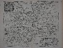
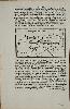
Imprint: London, 1673
Edition: First Edition 260 x 310 mm., with extreme upper right corner of margin missing, otherwise in good condition.
This attractive map is from the 'Britannia' which was intended as the third part of Richard Blome's grand atlas in four volumes announced in 1668. Lambasted by Bishop Nicolson in 1696 as 'a most entire piece of theft out of Camden and Speed' and by Richard Gough in 1780 as 'a most notorious piece of plagiarism'. Blome himself disclaimed originality claiming in the Preface 'I do not own myself the Author, but the Undertaker [i.e. publisher] of this work'. One should remember that this was the first edition of Camden's 'Britannia' to be issued with maps since the 1630s. Blome was one of the earliest to finance his works by subscription. One later edition of the work is known in 1677 which survives in just one known example. Shirley BL T.Blom-2a; Skelton 90.
Stock number:9057.
|
|
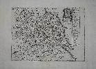
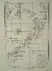
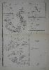
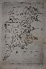
Imprint: London, 1670-[73]
Edition: First Edition 205 x 280 mm., large margins, in good condition.
This attractive map is from the 'Britannia' which was intended as the third part of Richard Blome's grand atlas in four volumes announced in 1668. Lambasted by Bishop Nicolson in 1696 as 'a most entire piece of theft out of Camden and Speed' and by Richard Gough in 1780 as 'a most notorious piece of plagiarism'. Blome himself disclaimed originality claiming in the Preface 'I do not own myself the Author, but the Undertaker [i.e. publisher] of this work'. One should remember that this was the first edition of Camden's 'Britannia' to be issued with maps since the 1630s. Blome was one of the earliest to finance his works by subscription. A later edition of the work is known in 1677 which survives in just one example. This map of the whole of Yorkshire dated 1670 bears the arms of Charles Lord Fairfax upper right. Shirley BL T.Blom-2a; Rawnsley 18; Skelton 90.
Stock number:7899.
|
|
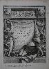
Imprint: Paris, Chez Lattré & Herissant, 1762
320 x 220 mm., light water stain upper right otherwise in good condition.
The title page Rigobert Bonne's 'Atlas Moderne' which was published in 1762. Bonne was an engineer, mathematician and cartographer. He succeeded Jacques Nicolas Bellin as the hydrographer at the Depot de la Marine. Jean Lattre was the publisher of this edition, he may also have been this maps engraver. Shirley BL T.Bonn 1a.
Stock number:8727.
|
|
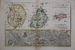
Imprint: Paris, c.1780
220 x 320 mm., wash colour, in good condition.
Rogobert Bonne's map of the three main Indian Sea islands of Reunion, Mauritius and Rodrigues. At the bottom is a general map showing their relation to each other with detailed maps of each above. That or Bourbon features the volcano erupting.
Stock number:9358.
|
|
Imprint: Padua, 1789
365 x 250 mm., in excellent condition, a very fresh example with a superb large watermark.
A fabulous example of an early map of New Zealand as newly charted by Captain James Cook and first published in 1773. This map by Rigobert Bonne (1727-95) is from the âAtlas Encyclopédiqueâ but not the usual Paris edition engraved by Gaspard Andre. This is the rarer map engraved by Pietro Scattaglia (c.1739-1810) who is described in Tooleyâs âDictionary of Mapmakersâ as an engraver in Venice. It also states that he engraved plates for the similarly entitled atlas published in Padua, 1789. Bonne was an engineer, mathematician and cartographer. He succeeded Bellin as the hydrographer at the Depot de la Marine. With insets of places noted during the voyage: Coromandel Peninsula, Cook Strait, Bay of Islands and Tolaga Bay. Phillips (1909-) 666; refer Shirley (2004) T.Bonn 6a.
Stock number:6286.
|
|
Imprint: Paris, 1771
410 x 290 mm., in early outline colour, in good condition.
From Rigobert Bonne's 'Atlas Moderne' first published in 1762 by Jean Lattre with maps from various cartographers. Bonne was an engineer, mathematician and cartographer. He succeeded Bellin as the hydrographer at the Depot de la Marine. Jean Lattre was the publisher of this edition, he may also have been this maps engraver. The map covers the famous French provinces of Champagne and Brie. Shirley BL T.Bonn 1a.
Stock number:5590.
|
|
Imprint: Paris, 1771
410 x 290 mm., in early outline colour, in good condition.
From Rigobert Bonne's 'Atlas Moderne' first published in 1762 by Jean Lattre with maps from various cartographers. Bonne was an engineer, mathematician and cartographer. He succeeded Bellin as the hydrographer at the Depot de la Marine. Jean Lattre was the publisher of this edition, he may also have been this maps engraver. The map covers the southern French provinces of Dauphine and Provence. Shirley BL T.Bonn 1a.
Stock number:5591.
|
|
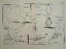
Imprint: Paris, c.1780
235 x 345 mm., in good condition.
This map displays a collection of charts of bays & islands in the South Pacific. It was published in Bonne's 'Atlas Encyclopedique'. It includes nine recorded by Capt. James Cook on his first two circumnavigation's between 1768-1775. The islands included are clockwise from top left Isles de Wallis, Isle Turtle, Cocos Islands, Isle Sauvage, Isle de Hervey, Palmerston Is., Isle de Pasques or Easter Island, Pitcairn Island and lastly Dusky Bay and Resolution Island in New Zealand. Phillips, P.L. (Atlases) 288.
Stock number:5748.
|
|
|
Imprint: Paris, c.1785
240 x 345 mm., in full colour, minor tear in lower margin repaired, not affecting the image.
With two insets of Isle de Georgie (South Georgia Islands) and Terre de Sandwich (South Sandwich Islands). Engraved by Andre for Bonne's "Atlas Encyclopedique". Phillips, P.L. (Atlases) 666.
Stock number:4481.
|
|
Imprint: Paris, c.1780
360 x 225 mm., in good condition.
This map is engraved by Gaspard Andre for Bonne's "Atlas Encyclopedique". Cartographically it draws upon Captain James Cook's accounts. Upper left is a chart of the bay of D'Awatska on the Kamtschatka coast with a part of the islands of Japan to its right. The most important part though is lower right which is a fine chart of the waters arround Macao. The town is laid out simply. It was visited by Cook's ship during the third voyage although without Cook who had been killed in Hawaii earlier in 1779. At the time the vessel was under the command of Gore and King. Each chart depicts coastal topography along with soundings, shoals, channels and some navigational notes. The route of Cook's vessels is illustrated with a line. Phillips, P.L. (Atlases) 666.
Stock number:7374.
|
|
Imprint: Venice, 1528
Two maps each 85 x 145 mm., on either side of a page of text, in old wash colour, in good condition.
Benedetto Bordone's 'Libro' is designed like a traditional 'Isolario' of the day, as a collection of maps of islands. This leaf contains a map of Limonia and nearby island which lie north west of Rhodes and on the verso the island of Alimnia. Armstrong in 'Imago Mundi' no. 48 pp. 65-92; Karrow pp. 89-93; Shirley Atlases in the BL T.Bord 1a.
Stock number:8595.
|
|
Imprint: Venice, 1528-[47]
Edition: First Edition 85 x 145 mm., small area of margin loss repaired in far upper right margin level with the text, otherwise good condition.
'This map appears in an atlas of the islands of the world, or 'Isolario' as they were called. The first atlas, issued in c.1485 by Bartolommeo dalli Sonetti, was confined to the eastern Mediterranean. The second, containing this map, covered the whole world. The first edition was entitled 'Libro di Benedetto Bordone'. All of the three subsequent editions of this work carried the title of 'Isolario'.Appearing on the reverse of page VI, the map lacks detail. It is purported to have been of Greenland but recent arguments by Suárez point to it being of the North American continent. The name given to this land mass is 'Terra de lavoratore' after João Fernandes of the Azores, who arrived at Cape Farewell, Greenland, in 1500. 'Stretto pte del modo novo' depicts the area corresponding to the latitude of the Caribbean, the land mass shown below it being South America. This is derived from the world map at the beginning of the atlas. The fictitious islands of 'brasil' and 'asmaide' appear here as they did on many maps of this period. Although clearly representing America the geography of the coastline is however derived from the north-east Asian one, the two often being interrelated at this time' (Burden 8). It is on a full sheet of Italian text with a map of Scandinavia on verso. An analysis of the text setting identifies this as being from the 1547 edition. Burden 8; Ginsberg 7; Karrow pp. 89-93; Shirley 'Atlases in the BL' T.Bord 1a; Suarez p. 66.
Stock number:5237.
|
|
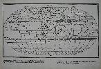
Imprint: Venice, 1528-[34]
240 x 385 mm., with very minor holes in the centrefold caused by the stitching of the book, a not uncommon occurrence, professionally restored, otherwise in good condition.
The 'Isolario', or book of islands, was a cartographic form introduced and developed in Italy during the 15th and 16th centuries. Like the portolano, or pilot-book, to which it was related, it had its origin in the Mediterranean, as an illustrated guide for travellers in the Aegean Archipelago and the Levant. Bordones 'Isolario' was the second to be printed and the first to give prominence to the transatlantic discoveries. Skelton quotes Almagia as saying that it is, in fact, the earliest complete work of its kind to have been produced by the printing-press in Italy or anywhere else. The 'Isolario' is divided into three books, devoted respectively to the islands and peninsulas of the western ocean, to the Mediterranean, and to the islands of the Indian Ocean and the Far East. While this order corresponds very roughly to that of Ptolemy, it gives conspicuous priority to the discoveries across the Atlantic. The most desirable map in the atlas is this classic oval world map, for many years thought to be the first printed in this projection. It is in fact derived from the exceedingly scarce Francesco Rosselli map of c.1508. However unlike the Rosselli, Bordone omits the unknown land at the South Pole and separates the continents of Asia and America. The six traditional wind directions are marked and named outside the map. This example is from the second of four editions which was published in 1534. It is the earliest obtainable world map in an oval projection. Provenance: acquired from Tooley Adams January 2012. Bordone (1460-1531) was a Paduan illuminator and wood-engraver who was apparently established at Venice by 1494. Skelton, TOT facsimile edition; Harrisse 'Bibliotheca Americana Vetustissima', no. 187; Nordenskiöld, A.E. (Facsimile) pp. 103-4; Shirley World 59; Skelton Introduction to facsimile edition; World Encompassed no. 83.
Stock number:9082.
|
|
Imprint: Venice, 1528-[34]
Edition: First Edition 85 x 150 mm., in good condition.
FIRST EDITION. Benedetto Bordone's 'Libro' is designed like a traditional Isolario of the day, as a collection of maps of islands. This leaf contains a map of the Crimean peninsula and surrounding country of Russia and Ukraine. Armstrong in 'Imago Mundi' no. 48 pp. 65-92; Karrow pp. 89-93; Shirley 'Atlases in the BL' T.Bord 1a no. 23.
Stock number:9604.
|
|
Imprint: Boston, October 1784
240 x 155 mm., with top right margin replaced not affecting the image, a couple of minor fold splits in the margin repaired, otherwise in good condition.
This rare AMERICAN PRINTED plan of Boston was published in the Boston Magazine in October 1784 just after the conclusion of the American Revolution. The Magazine began publication in November 1783 and folded in October 1786. Its aim was to compile a magazine for the town of Boston and was compiled by John Bradford, John Clarke, Aaron Dexter, John Eliot, James Freeman, Christopher Gore, Benjamin Lincoln, George Minot amongst others. There were a number of publishers also including Edmund Freeman, Joseph Greenleaf, James White and John Norman. The latter is most likely responsible for this plan.Norman (1748?-1817) was one of the early pioneers of American cartography and behind the publication of the first American printed wall map in 1785, Thomas Hutchins great map of 1787, the charts for Matthew Clarks Charts of the Coast of America in 1790 and several works of Osgood Carleton. Born in England around 1748 it is believed he was apprenticed to the London printer William Faden, father of the cartographer of the same name. He arrived in Philadelphia first in 1774 before moving to Boston in 1780. The Magazine featured a supplement on an irregular basis entitled the Geographical Gazetteer of Massachusetts, the issue of October 1784 included this map. It is derived from another similarly entitled plan engraved by John Norman published in An Impartial History of the War in America the same year. Although here the engraved is unidentified the fact that Norman was one of its publishers does not rule out his having engraved this derivative. A rare survivor of early American magazine printing. Ristow "American Maps and Mapmakers" pp. 224-7; Wheat & Brun 242; Worms & Baynton-Williams (2011).
Stock number:8388.
|
|
|
Historical Descriptions of New and Elegant Picturesque Views of The Antiquities of England and Wales
Imprint: London, Alexander Hogg, at the King's Arms, No. 16, Paternoster-Row, and Sold by all Booksellers, Printsellers, and News-Carriers, in Town and Country, c.1787-89
Edition: First Edition Binding: Hardback Inscription: Signed, Inscribed Or Annotated Folio (385 x 245 mm.), full contemporary tree calf, decorative floral gilt panelled boards, rebacked preserving the original spine with raised bands, ornate gilt ruled compartments, red calf gilt title, marbled endpapers, light wear. With engraved frontispiece, recto blank, typographic title page, with intervening contemporary tissue, Preface signed by Boswell, Index List of the Plates, List of Subscribers, pp. iv, 42, numerous unpaginated typographic descriptions, (8), with c.195 copper plate engravings and 50 maps including 40 of the English counties, maps of South Wales, North Wales and 8 further plates of maps of the Scottish districts and Irish provinces, in good condition.
FIRST EDITION. Alexander Hogg (fl.1778-1809) began working for John Cooke who was a major publisher of serialised part works. In 1778, he started out on his own in competition. Adams stated, âa favourite pastime of both Cooke and Hogg was the invention of elegant aliases for the authorship of their topographical "sixpenny numbersâ which must in fact have owed their existence to the attic labours of a consortium of sweated Grub Street hacksâ. These writers compiled these works by plagiarising existing publications and offering them as weekly parts of 6d. The original title page stated that this work was âpublished under the inspection of Henry Boswell, Esq. F.A.R.S. Assisted by Robert Hamilton, L.L.D.â Cooke publicly accused Hogg of fabrication when he announced in 'The World' 1-2 October 1788 that there was no Henry Boswell at the F.R.A.S. (Fellows of the Royal and Antiquarian Societies). Although Hogg defended other charges, he never denied this one.'The Antiquities of England and Wales' is effectively an abridgement of the six volumes published by Francis Grose. Hodson writes that Hogg had taken over the 'London Magazine' after the publication of the volume for January to June 1785. It was at this point that no doubt he also became the owner of the copper plates by Kitchen used in 1747-63 to illustrate a set of English and Welsh counties. The parts for Hogg's work were first advertised on the verso of the title to the third volume of the 'New London Magazine' for 1787 and published in January 1788. Ten numbers were available at the price of 6d. each. This would indicate initial publication of the weekly sometime in October 1787. The one hundred parts were completed early as the 'Glocester Journal' of 16 February 1789 announced that the completed work was available âelegantly bound in calf and lettered, price 3l.â Of the 50 plates, 40 are of English counties, all but one were originally published in the 'London Magazine'. All references to the work are removed. Those of Yorkshire, North and South Wales, the Orkneyâs etc. and Ulster were all previously published in Hoggâs 'New British Traveller' in 1784. Those of the remainder of Ireland and Scotland were engraved on 6 new plates. This example is bound such that the maps follow the descriptions and illustrations of the Antiquities. Each map is accompanied by a single leaf of descriptive text. Both the Index and Subscribers List are present which is not always the case. The Index to the plates in the work is broken down into the 100 parts issued. The list of names on the Subscribers List on inspection appears to be quite genuine. Provenance: manuscript ownership on front free endpaper 'Mary Yeeles 1792'; below is a further inscription of 'Gilbert Price, 5 Cleveland Pl. Bath; Hugh Fattorini collection with bookplate affixed inside upper board; Sotheby's 30 April 2015 lot 123; private English collection. Adams (1983) p. xv; Chubb (1927) 257; ESTC T122443; Hodson (1984-97) 281; Shirley (2004) G.Hogg 2a; Worms & Baynton-Williams (2011).
Stock number:10173.
|
|
Imprint: Paris, 1787
215 x 170 mm., in good condition.
This chart of the harbour of Trincomalee in Sri Lanka is from the French 'Histoire de la Derniere Guerre, entre la Grande-Bretagne, et les États-Unis de l'Amerique ... 1775, jusqu'a sa fin en 1783' by Odet-Julien le Boucher. Published in 1787 it is a rare work. Boucher was an eminent French historian whose reputation was built on this work. Howes describes it as the best French chronicle of the wars. Howes L169; Sabin 6840.
Stock number:6379.
|
|
|
Imprint: London, 1885
Binding: Hardback Folio, two volumes (365 x 270 mm. each), full contemporary brown cloth, gilt titles to spines, gilt ownership name to upper cover. With title pages to each: Part I, Counties pp. 196, with 50 largely folding county maps in early outline colour; Part II, Boroughs pp. 100, with 37 largely folding plans, in early outline colour, in good condition.
An early issue of the Boundary Commission report of 1885 before the inclusion of a plan of Salisbury which is replaced by a Memorandum slip stating that one 'is in preparation, and will be issued shortly'. The Commission reported on proposed boundary changes to the election of Members of Parliament. It was the third occasion in which an attempt was made to equalise the representation of the population across the United Kingdom in the Houses of Parliament. The first major reform was undertaken in the Reform Act of 1832. This was followed by another distribution during the Reform Acts of 1867 and 1868 which proved unsatisfactory. By 1885 the industrial growth of the country and the population movements this encouraged, had made the imbalance worse. This third Bill was the result of long and difficult negotiations between William Gladstone of the ruling Liberal Party and Lord Salisbury of the Conservative Party. It required the intervention of Queen Victoria to settle the course of action.The Reform Bill of 1885 was to draw upon the Ordnance Survey maps in order to determine the boundaries of divisions. The direct consequence of the Bill was the decline of the control of Parliament by the aristocracy. For the first time the number of MPs who represented industry and commerce outnumbered those connected with the landed gentry. The first volumes contains all of the English counties and four Welsh counties as called for. They are all bound in strict alphabetical order. Those of the West Riding are divided into three separate maps and those of Lancashire into four. Of the Boroughs, 15 relate to London. This report appears to be extremely rare, indeed this example is the last complete one we could find in auction having sold at Sotheby's on 6 December 1976. It is one of the most influential 'atlases' in British history. This example once belonged to Joseph F. B. Firth who wrote on the 'Reform of London Government and of the City Guilds' in 1888. Provenance: gilt ownership of 'Joseph F. B. Firth' on both covers; withdrawn stamp from Croydon Public Library with their blindstamp to margins of many maps; private English collection. Smith (1985) XIV.
Stock number:9953.
|
|
|
Imprint: London, 1885
Binding: Hardback Folio (355 x 270 mm. each), modern cloth binding, spine with gilt ruled compartments and title, later endpapers. Part I, Counties pp. 196, with 50 largely folding county maps in early outline colour, in good condition.
An early issue of the Boundary Commission report of 1885. The Commission reported on proposed boundary changes to the election of Members of Parliament. It was the third occasion in which an attempt was made to equalise the representation of the population across the United Kingdom in the Houses of Parliament. The first major reform was undertaken in the Reform Act of 1832. This was followed by another distribution during the Reform Acts of 1867 and 1868 which proved unsatisfactory. By 1885 the industrial growth of the country and the population movements this had encouraged, had made the imbalance worse. This third Bill was the result of long and difficult negotiations between William Gladstone of the ruling Liberal Party and Lord Salisbury of the Conservative Party. It required the intervention of Queen Victoria to settle the course of action.The Reform Bill of 1885 was to draw upon the Ordnance Survey maps to determine the boundaries of divisions. The direct consequence of the Bill was the decline of the control of Parliament by the aristocracy. For the first time the number of MPs who represented industry and commerce outnumbered those connected with the landed gentry. This is the first volume only, containing the complete set of county maps. Volume two included town plans and volume three covered Scotland and Ireland. A good example of one of the most influential 'atlases' in British history. Batten & Bennett (2010) 162; Carroll (1996) 139; Smith (1985) pp. 133-4, XIV.
Stock number:10329.
|
|
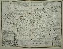
Imprint: London, 1753-[c.64]
54 x 70 cms., early ourline colour. A lovely fresh example.
Arguably the finest English county map of the eighteenth century from ' The Large English Atlas'. Thomas Kitchin was one of the most notable English cartographers of the eighteenth century. He was both an engraver and publisher of considerable reputation who was made Hydrographer to King George III. He worked with many of his contemporaries on various projects. This map of Cheshire is Hodson's state e, or 5 of 6, with the imprints of John and Carington Bowles and Robert Sayer. Hodson 221 pp. 97-147; Shirley 'Atlases in the BL' T-Bow 3a.
Stock number:3471.
|
|