|
|
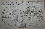
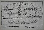
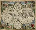
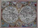
Imprint: London, William Berry at ye Sign of the Globe between Charing Cross and Whitehall, 1680
575 x 885 mm., in early outline colour, some professional repair to edge tears and reinforcement to lower corners, not affecting the image, with the accompanying page of geographical tables, otherwise in good condition.
A fine rare English double-hemispheric seventeenth century world map. In September 1678 Robert Morden (fl. 1669, d. 1703) and William Berry (1639-1718) petitioned the crown for a licence to do all general and particular maps of the several parts of the world according to an alphabeticall manner. Mordens connection with what appears to be the birth of the folio atlas is not heard of again. Berry began publishing a series of large two sheet maps with a group of the world and continents advertised in the London Gazette, from 1-5 July 1680. The world is also announced in the Term Catalogues for the summer of that year. This only mentions the world map, which would undoubtedly have been finished first, and the continents would have followed. Berry did not advertise his next two sheet map, that of England, until February 1682.Through the 1680s Berry published nearly forty large maps of parts of the world, sufficient to cover it all. From the late 1680s he clearly offered them bound together as a collection of maps as a handful of examples are known, but this was clearly not the intention for the maps, as none have borne any title page. Examples are known in the British Library, the Library of Congress and the National Maritime Museum, Greenwich, all bearing either thirty-seven or thirty-eight maps. An example has been noted for sale by Maggs Brothers, which bore sixty-nine maps, the balance being made up of contemporary English maps by other cartographers dating the atlas to c.1704, and two further offered at Christies, auctions in London in the 1980s (Burden). Cartographically the world map is drawn directly from that of Alexis-Hubert Jaillot, 1674. Jaillots map was, in turn, derived from Nicolas Sansons geography, who is here recognised in the running title above, Described by Sanson Corrected and amended By William Berry. Sanson had far more of a reputation in cartographic circles than Jaillot so it is natural that Berry would use his name. These amendments include the patriotically named islands off Tierra del Fuego and New Albion placed in California. New Guinea is distinctly an island and there is no southern continent. An ornate cartouche lower centre includes an effusive dedication to Charles II. Armitage (2012) pp. 41 & 99-100; Burden (1996-2007) 532; Phillips (1909-) 3442; Shirley (1984) 501; Shirley (2004) T.Berr 1a; Tyacke (1973) p. 76; Tyacke (1978) no. 100 & pp. 109-10.
Stock number:7758.
|
|
Imprint: Amsterdam, 1616
Inscription: Signed, Inscribed Or Annotated 100 x 135 mm., in fine condition.
This attractive little map of the world according to the Egyptian geographer Ptolemy was published in Amsterdam by Petrus Bertius. It displays a ptolemaic geography with climatic zones identified. The work it comes from is a revised edition of Barent Langenes' 'Caert Thresoor' entitled 'Tabularum Geographicarum Libri ...' The maps were all newly engraved by Jodocus Hondius, this example is signed by him and has Latin text on the verso. King (2nd ed.) pp. 96-99; Van der Krogt, P. (Atlantes) 6281:342; Shirley 'Atlases in the BL' T.Bert 2a.
Stock number:8602.
|
|
Imprint: Amsterdam, 1606-[c.1640]
410 x 550 mm., in early wash colour, light even toning, a slight area of offset in upper central vignette otherwise a good example.
Willem Janszoon, or Blaeu as he was later to be known, had been issuing separately published maps since 1604. The only atlases he was producing at this time were of the sea. In 1606 he produced this CLASSIC SINGLE SHEET MAP OF THE WORLD on Mercators projection. This map arguably more than any other helped to popularise the by now nearly fifty year old projection. It is celebrated as one of the supreme examples of the map makers art (Shirley). Schilder praises the map very highly stating that the balanced composition and elegant ornamentation make this world map one of the small masterpieces of the seventeenth century.Cartographically it is drawn from Blaeus own double-hemispheric projection 20-sheet wall map, the sole surviving example is in the Hispanic Society of America, New York, in rather poor condition. Its engraver is believed to be Joshua van den Ende who also produced this single sheet map. The wall map was published at the behest of the Dutch States-General who encouraged Blaeu to utilise the very latest knowledge. As a result it is the most accurate world map published to date. Because Mercators projection particularly distorted the higher latitudes Blaeu incorporates in the lower corners two hemispherical maps of the Polar Regions. It is dedicated to Cornelis Pietersz Hooft (1547-1626) a wealthy administrator and merchant in Amsterdam. At the same time Blaeu was working on a four-sheet version also in Mercators projection. This map was known in just two examples prior to the Second World War and both were lost in the conflict. In 1980 the four map sheets alone were discovered in Berne, Switzerland.In 1617 the results of Jacob le Maire and Willem Cornelisz Schoutens voyage around Cape Horn became known. They showed that Tierra del Fuego was an island and not connected to the unknown southern continent. Owing to law suits that were filed between the Australian Company and the Dutch East India Company, Blaeu was legally barred from incorporating this new information on his maps and globes in July 1617. This restriction was not lifted until August of the following year. Blaeu immediately updated this work to include Fretum Magalanicum and State landt. The first three states of the map were separately published and as such are of extreme rarity. It is the fourth state which was incorporated into Blaeus first folio terrestrial atlas, the Atlantis Appendix of 1630. This was Blaeus first attempt at a world atlas, largely instigated by his purchase in 1629 of a number of Jodocus Hondius plates, and in the following years he would experiment with various formats. The Atlas Novus as it would become was issued from 1635 to 1658 expanding along the way to consist of six volumes. This maps popularity rests on its association with arguably the greatest Dutch cartographer of all time. One of the classic features of the map is the four decorative border panels. Above are seven allegorical images of the sun, moon and the five planets known. The left side features four vignettes of the elements - Fire, Air, Water and Earth. The right displays the four seasons. Matching the seven vignettes above are seven below of the wonders of the world. Schilder in his Monumenta IV details magnificently the origin of much of this imagery. Blaeu died in 1638 and the business passed to his sons, Cornelis and Joan. The latter particularly carried the family name and was the driving force behind the multi-volume Atlas Major. Provenance: private English collection since the 1970s. Van der Krogt (1997-2003) 0001:2A; Shirley (1984) 255, state 4; Schilder (1993) 10.4 pp. 41, 171-83; Schilder (2000) 1.4 pp. 86-9.
Stock number:6212.
|
|
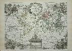
Imprint: Amsterdam, 1662
Edition: First Edition 410 x 545 mm., early wash colour, some light toning in the margins due to previous framing, one small wormhole in upper margin, otherwise in good condition.
A classic double-hemisphere world map here in its FIRST EDITION published with Latin text in Joan Blaeuâs magnum opus, the âAtlas Majorâ. Joan Blaeuâs father Willem Blaeu first published the Mercator projection world map in 1606 and had been included in the Blaeu firmâs atlases from 1630. This newly engraved double-hemispheric map was produced for the âAtlas Majorâ, the monumental work is considered the greatest of all atlases. âThe Great Atlas by the Blaeuâs is one of the monuments of map production, and for size and beauty and accuracy has never been surpassedâ (World Encompassed no. 149). âThe contents of this unprecedented atlas illustrate the high standards of contemporary cartography and geographical knowledge, and its presentation bears witness to the superb craftsmanship of engraver, printer, binder, and papermakerâ (Koeman (1970) Joan Blaeu and his Grand Atlas, pp. 1-3).Cartographically it resembles his own large wall map of 1648 with new additions, specifically in the west coast of North America. California is still depicted as an outline but now with a flatter north coast known as the Briggs type. Similarly, a reference to Sir Francis Drake and Anian are also additions here. The map is surrounded by spandrel vignettes which incorporate allegorical images of the four seasons and celestial figures. The four seasonal characters are seen sitting in chariotâs, from left to right; spring, summer, autumn and winter. Each are drawn by various fauna. An image of Galileo Galilei sits over the western hemisphere whilst Tycho Brahe is to the right. Koeman (1967-70) Bl 56 no. 435; Van der Krogt (1997-2010) (Vol. II) 0001:2B; Shirley (1984) 428.
Stock number:9126.
|
|
Imprint: Venice, 1528-[34]
240 x 385 mm., with very minor holes in the centrefold caused by the stitching of the book, a not uncommon occurrence, professionally restored, otherwise in good condition.
The 'Isolario', or book of islands, was a cartographic form introduced and developed in Italy during the 15th and 16th centuries. Like the portolano, or pilot-book, to which it was related, it had its origin in the Mediterranean, as an illustrated guide for travellers in the Aegean Archipelago and the Levant. Bordones 'Isolario' was the second to be printed and the first to give prominence to the transatlantic discoveries. Skelton quotes Almagia as saying that it is, in fact, the earliest complete work of its kind to have been produced by the printing-press in Italy or anywhere else. The 'Isolario' is divided into three books, devoted respectively to the islands and peninsulas of the western ocean, to the Mediterranean, and to the islands of the Indian Ocean and the Far East. While this order corresponds very roughly to that of Ptolemy, it gives conspicuous priority to the discoveries across the Atlantic. The most desirable map in the atlas is this classic oval world map, for many years thought to be the first printed in this projection. It is in fact derived from the exceedingly scarce Francesco Rosselli map of c.1508. However unlike the Rosselli, Bordone omits the unknown land at the South Pole and separates the continents of Asia and America. The six traditional wind directions are marked and named outside the map. This example is from the second of four editions which was published in 1534. It is the earliest obtainable world map in an oval projection. Provenance: acquired from Tooley Adams January 2012. Bordone (1460-1531) was a Paduan illuminator and wood-engraver who was apparently established at Venice by 1494. Skelton, TOT facsimile edition; Harrisse 'Bibliotheca Americana Vetustissima', no. 187; Nordenskiöld, A.E. (Facsimile) pp. 103-4; Shirley World 59; Skelton Introduction to facsimile edition; World Encompassed no. 83.
Stock number:9082.
|
|
Imprint: London, c.1730
360 x 220 mm., in good condition.
This is at first glance an index of contents to the 'World Described' by Herman Moll, his double folio world atlas. From about 1730 examples were sold by John Bowles (1701-79), one of the most active of the Bowles family of map and print sellers which dominated much of the eighteenth century. Although this is a contents list for the atlas it bears below a list of other publications some of which have no connection to Herman Moll. The list is therefore a John Bowles production. It offers 'A Sett of fifty new and correct Maps of England and Wales' first published in 1724, 'A Sett of Thirty-six new and correct Maps of Scotland' first published in 1725, 'A Sett of Twenty new and correct Maps of Ireland' first published in 1728, the 'Geographia Antiqua' first published in 1721, the 'Britannia Depicta' from 1720 and lastly the 'Atlas Minor' first published in 1729. Worms and Baynton-Williams cite that Bowles however moved to the Black Horse in Cornhill in 1730. These broadside sheets were issued for distribution and as such have an appalling survival rate unless as is likely here it was pasted inside an atlas at some time. Worms & Baynton-Williams (2011).
Stock number:8672.
|
|
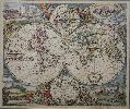
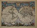
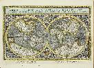
Imprint: Amsterdam, c.1685
485 x 580 mm., early wash colour, with lower centrefold split and smaller nearby tear into the image repaired, area of light foxing lower right, otherwise in good condition.
Sometime after 1684 the firm of Danckerts were granted a privilege protecting their works. Soon after Justus Danckerts published this attractive double hemisphere world map. California is depicted with a double bay northern shore and above that is Terra Esonis the confused coastline common amongst cartographers of the day. New Guinea is depicted as an island with the York Peninsula below it, the remainder of Hollandia Nova is found on the eastern hemisphere. The whole is finished with polar hemispheres top and bottom and attractive allegorical scenes in the four corners. There is only one recorded state of the plate. It is unclear which Justus Danckerts was responsible for the plate, father or son. Provenance: private English collection since 1978. Shirley (1984) 529.
Stock number:7755.
|
|
|
Imprint: Frankfurt, 1599
Edition: First Edition 120 x 225 mm., in full wash colour, with repaired tear in lower right corner, not affecting the image, otherwise in good condition.
This is Theodore De Bry's reduction of Jodocus Hondius' broadside map illustrating the circumnavigation of Sir Francis Drake's in 1577-1580. It illustrates Drake's route using tiny ships along the route to denote the direction of travel. Around the map are a portrait of him at the top and illustration of his ship below. The map is further embellished with sea monsters and elegant strap work. The exact date of the original Hondius-Drake broadside is not known but believed to be the work of Jodocus Hondius, circa 1595. This particular map appeared in several editions of De Bry's 'America' Part VIII, beginning in 1599. The present example was the title page to the first edition in Latin, 1599. The work described three voyages by Sir Francis Drake, one by Henry Cavendish and two by Sir Walter Ralegh. As the Hondius broadside is virtually unobtainable, the present map is highly sought after among collectors. Church I 163 illustrated pl. 163; Shirley 219 and refer to 188.
Stock number:9411.
|
|
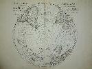
Imprint: Paris, 1714
48 x 52 cms. each, two maps, early outline colour
A pair of maps in their first state of the polar hemispheres. The northern displays California as a peninsula and a spartan northern Pacific. The south polar map depicts the routes of explorers including Tasman. These highlight one of the features that De L'Isle is most highly regarded for, that being to leave blank any area for which no knowledge was known. Earlier cartographers were wont to insert guesswork coastlines and topographical features. From the 'Atlas Nouveau'. Good impressions. Clancy 6.26; Tooley Australia no. 1512; Wagner (NW) no. 504
Stock number:3205.
|
|
Imprint: Amsterdam, c.1670
480 x 570 mm., in fine early wash colour, remnants of mounting tape to the verso, otherwise in good condition.
De Wits map is one of the most attractive of its time (Shirley). Accurate dating of the publication of Frederick de Wits double-hemisphere world map is not possible as his atlases are undated and we have no further concrete knowledge. Shirley suggests that based on the cartographic depictions of Hudsons Bay that this map might even pre-date his maritime world map of 1668. De Wit (1630-1706) was one of the most successful Dutch engravers and map publishers of the second half of the seventeenth century. He had already published three wall maps of the world by 1670, in twelve, four and eight sheets. This attractive double-hemisphere map is renowned for its decoration. It bears two polar projection insets top and bottom and the surrounds are filled with allegorical designs incorporating the four elements, four seasons and the signs of the zodiac. This second state bears cherubs in the cusps between the hemispheres. The map was included in the composite de Wit atlases of the period and can also be found in those of other rival Dutch publishers such as Nicolas Visscher, the heirs of Jansson. A good clean example of a classic Dutch piece of cartographic art which was much copied by later cartographers. Provenance: private English collection since 1985. Koeman (1967-70) Wit 1; Shirley (1984) 451 st. 2.
Stock number:6213.
|
|
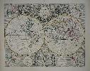
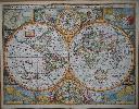
Imprint: Paris, 1748
220 x 300 mm., early outline colour. With small repair to tear in extreme lower right margin, not affecting the image.
A lovely double hemisphere world map with four ornate scenic cartouches. George Louis Le Rouge was a military engineer who took up cartography from about 1740. From the 'Atlas Nouveau Portatif a l'Usage des Militaires, et du Voyageur'.
Stock number:4581.
|
|
|
Imprint: G. and W. B. Whittaker, 1822
275 x 375 mm., early outline colour, folded as issued with repair to a couple of fold splits and bookbinders tear, otherwise in good condition.
This map accompanied an account of the scientific voyage and whaling classic of the 'Baffin' by Captain William Scoresby (1789-1857) to the waters of the North Atlantic. Scoresby was an arctic scientist and clergyman, the son of William Scoresby (1760-1829) an arctic whaler. He made his first voyage to the arctic with his father when he was just ten years old. Apprenticed to his father in 1803 he made annual trips to the whale fisheries each summer until 1823. In 1806 they reached a record 81 degrees 30 minutes north. In 1806 he enrolled at Edinburgh University and spent the winters studying. The University encouraged him to undertake research during his voyages. He even received suggestions from Sir Joseph Banks. In 1810 he took command of his father's ship, the 'Resolution'.From 1813 to 1817 he was in command of the larger 'Esk' and made numerous important discoveries. He suggested to Banks that a government sponsored exploration of the arctic should occur. It did, but under the command of the navy. In 1819 he moved to Liverpool to oversee the construction of the whaler, 'Baffin', which he had designed. He had designed a new harpoon gun which proved very successful. So much so that the crew felt it was a threat to their livelihood. The 'Journal of a voyage to Greenland, in the year 1821', published in 1822 included many fine illustrations and this chart. All of them were produced by the new lithographic process and are very early examples by James Duffield Harding (1797-1863) and printed by Charles Joseph Hullmandel (1789-1850).The Journal itself is written by George William Manby (1765-1854), fellow of the Royal Society, who accompanied Scoresby on the voyage. The track of the voyage is recorded taking them first to Spitzbergen, then along the coast of Greenland, to Iceland before returning home. Manby's account of whaling is a classic providing a vivid picture of the practice. In 1822 Scoresby mapped the East coast of Greenland which brought him much acclaim. He also attracted the attention of Humphry Davy whose was interested in his research on magnetic variation. The 'Baffin' went on to sink in 1830, a year in which 19 out of 90 ships in the whaling fleet were lost to terrible weather in the Davis Strait. Arctic Bib. 10844; ODNB; Sabin 44195.
Stock number:10100.
|
|
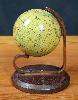
Imprint: London, 1857
A globe 65 mm. (2.5 inches) in diameter and made of papier mache with a plaster coating and 12 copper engraved printed paper gores running from north to south poles affixed, hand-coloured and varnished by the publisher. The sphere is mounted by the use of two polar metal pivots on to a plain brass meridian half-circle on a wooden stand, the whole standing 100 mm high. In good condition.
According to Elly Dekker James Manning was producing globes between 1854 and 1863. This particular one is dated 1857 and includes the new state of Victoria in Australia but was issued before the creation of Queensland. Manning published globes up to 12 inches in diameter principally for educational purposes. Dekker, Elly. (1999). 'Globes at Greenwich'.
Stock number:8184.
|
|
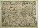
Imprint: Venice, 1596
160 x 245 mm., in outline colour, with light foxmark to right, otherwise in good condition.
For this new edition of Ptolemys Geography edited by Giovanni Antonio Magini, a noted geographer from Padua, this double hemispheric world map was engraved. it is neatly engraved by Girolamo Porro derived from the Rumold Mercator map of 1587. A tremendous amount of detail has been included with magnificent detailed engraving. The atlas contains the 27 Ptolemaic plates and a further 36 modern maps of the world. The work is often found lacking this initial Mercator world map. Provenance: The Map House 1973; private collection of Rodney Shirley. Nordenskiöld (1979) no. 223; Nordenskiöld (1889) p. 27; Phillips (1909-) no. 436; Sabin (1868) no. 66508; Shirley 'world' 194; Shirley 'Atlases in the British Library' T.Ptol 12a; Wagner (1937) no. 186.
Stock number:9480.
|
|
Imprint: Ulm, 1692-[c.1703]
65 x 80 mm., in good condition.
In 1692 Johann Ulrich Müller (1633-1715) published a small geographical work entitled 'Geographia Totius Orbis Compendiaria'. It appears the maps were engraved by a member of the Bodenehr family. This example is from the virtually unrecorded smaller format edition without text on the page published by Gabriel Bodenehr entitled 'Atlas Minor sive Orbis Terrae'. No date is to be found on the title but c.1703 is presumed. The map depicts the northern hemisphere to a latitude of 50 degrees north. Refer to King (2003) pp. 25 & 160B1; refer Phillips (1909-) no. 512; refer Shirley (2004) T.Mull-1a.
Stock number:8302.
|
|
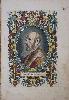
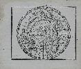
Imprint: 1579
325 x 220 mm., later wash colour, with some marginal light waterstain and minor crease, neither affecting the image, otherwise in good condition.
This is one of the most famous portraits of a cartographer. Engraved by Philip Galle, it is of Abraham Ortelius (1527-98) at the age of about 50. It was first published in his atlas the 'Theatrum Orbis Terrarum' in 1579. A fine ornate portrait likely taken from the painting by Paul Rubens currently displayed in the Plantin-Moretus Museum. Hind I p. 157. pl. 91; Van den Broecke (1996) pp. 14-15.
Stock number:8818.
|
|
|
Imprint: Strasbourg, 1513
190 x 290 mm., woodcut, with light browning to top and bottom edges, with very minor lower fold splits repaired, otherwise in good condition.
Gregor Reisch (c.1470-1525) was an Abbot at the Carthusian Monastery in Freiburg and noted mathematician. He also studied Hebrew and geography and became Confessor to the Emperor Maximilian I. Whilst there he taught Martin Waldseemuller and Sebastian Munster. He was the author of one of the most popular books on moral and natural philosophy entitled the Margarita Philosophica first published in Freiburg in 1503. Their ensued several editions published in Freiburg, Strasbourg and Basel. Shirley identifies four different woodcut maps which appeared in these. Most of them include a Ptolemaic world map. Two of the maps are modern and include America. The first of these offered here is listed in Shirley as being a Strasbourg edition of the work printed by J. Gruninger in 1513. The earliest reference I can find is in Nordenskiolds Facsimile Atlas of 1889. Bagrow and Skelton refer to the same edition for the map in History of Cartography 1964. However, I have been unable to find a listing for this edition. Of all the maps found in Reischs Margarita, the two modern ones of 1513 and 1515 are least likely to be present and are thus the scarcest of those cited (Shirley).The map is very rare and if dated to 1513 takes on some significance as it displays both North and South America in the same year as Waldseemullers great Ptolemaic atlas was published. It is a simplified version of Waldseemullers magnificent twelve sheet wall map of the world published in 1507 surviving in just the one example. It is updated with the latest geography from the modern portion of the Ptolemy. This is particularly notable from the depiction of Asia and the presence of North America. Residing now at the Library of Congress it is famous for being the earliest to record America.The map breaks down the areas of the world with simple straight lines. Larger areas are named, smaller ones are letter keyed to a typographic table below the map. North and South America are connected by a land bridge but the only name appearing is paria seu prisilia referring to Brasilia. Provenance: private English collection for 40 years; Bagrow & Skelton (1964) p. 126; Nordenskiold (1889) Facsimile pp. 42, 70 & 92; Shirley (1993) no. 36 and 22; Shirley (2003) An Unusual Find, in IMCoS Journal 92 pp. 27-9; Tooley Dictionary.
Stock number:9149.
|
|
Imprint: London, Damms Antikvariat, 1721
420 x 540 mm., early outline colour. With a small centrefold split at the bottom, repaired, not effecting the image. Otherwise a good example.
This is one of the earliest and most affordable English double hemispheric world maps from the "New General Atlas", 1721. One interesting and notable feature of the map is the inclusion of faint lines displaying earlier knowledge of the various continents whereabouts. This shows up the advances in cartography that had been made to date and enhances the perceived accuracy of Senex's map. Despite this however Senex still displays the idea that California is an island. The Mississippi River is also placed to far to the west. The whole is ornately decorated with four varying projections in each corner and is topped by an extremely ornate title cartouche with female figures representing the four continents, that of Europe is busy mapping the world. This part is uncoloured as it should be in the atlas. It is dedicated to the Prince of Wales, later to become King George II. The bottom of the map bears figures of Atlas and Hercules supporting an armillary sphere.John Senex (c.1678-d.1740) was geographer to Queen Anne and a Fellow of the Royal Society. He began his career as a book seller later becoming an engraver and publisher. In 1714 he published the large folio "English Atlas" which was followed by the folio "New General Atlas" of 1721 offered here. The proposal for the atlas was advertised in the "London Gazette" for 1418 October 1718, announcing its publication "shall be finished by Easter Term next". It did not appear until 1721. It is one of the earliest of all English world atlases and is particularly noted for its American content. Sabin noted that the atlas was "chiefly interesting for the copiousness of its information concerning America". Sanderson no. 434; Shirley, R.W. (BL Atlases) T.SEN-2a, #1.
Stock number:7048.
|
|
Imprint: London, Sold by Tho:Bassett in Fleetstreet and Richard Chiswell in St. Pauls Church Yard, 1627-[76]
420 x 560 mm., in full recent wash colour, in excellent condition with good margins all round.
A very attractive example from the most prestigious English world atlas of the seventeenth century by John Speed (1552-1629). This is Speeds classic representation of the world surrounded by allegorical border depictions of the four elements. The alignments of the Heavens and Elements, Figure of the Spheare and illustrations of a solar and lunar eclipse appear in the four corners. Two attractive hemispheres of the heavens are in the centre and the whole is finished off with roundel portraits of the first four circumnavigators.Speed is the most famous of all the English map-makers. His two most celebrated publications are The Theatre of the Empire of Great Britain covering the British Isles, first published in 1611[12] and the Prospect of the Most Famous Parts of the World, first published in 1627. Speed was a tailor by profession with a great interest in history and maps. He wanted to produce an English atlas of the same high standards and quality as those published on the continent. The Prospect of the Most Famous Parts of the World was published in 1627, two years before the death of Speed. Ownership of the atlas passed through various hands until sometime after 1668 when Roger Rea sold the rights to Thomas Bassett and Richard Chiswell. Bassett was a specialist in legal books and Chiswell was the publisher for the Royal Society. The final 1676 edition of the Prospect includes eight further maps on seven sheets appearing for the first and only time. Phillips (1909-) 488; Shirley (1984) 317; Shirley (2004) T.Spe 1j; Skelton (1970) 92; Wing (1945-51) S4886.
Stock number:5309.
|
|
Imprint: London, Sold by Tho:Bassett in Fleetstreet and Richard Chiswell in St. Pauls Church Yard, 1627-(76)
420 x 560 mm., in fine old but not original colour, two minor marks in upper margin otherwise in good condition.
A fine world map from the most prestigious English world atlas of the seventeenth century by John Speed (1552-1629). This is Speeds classic representation of the world surrounded by allegorical border depictions of the four elements. The alignments of the Heavens and Elements, Figure of the Spheare and illustrations of a solar and lunar eclipse appear in the four corners. Two attractive hemispheres of the heavens are in the centre and the whole is finished off with roundel portraits of the first four circumnavigators.Speed is the most famous of all the English mapmakers. His two most celebrated publications are The Theatre of the Empire of Great Britain covering the British Isles, first published in 1611[12] and the Prospect of the Most Famous Parts of the World, first published in 1627. Speed was a tailor by profession with a great interest in history and maps. He wanted to produce an English atlas of the same high standards and quality as those published on the continent. The Prospect of the Most Famous Parts of the World was published in 1627, two years before the death of Speed. Ownership of the atlas passed through various hands until sometime after 1668 when Roger Rea sold the rights to Thomas Bassett and Richard Chiswell. Bassett was a specialist in legal books and Chiswell was the publisher for the Royal Society. The final 1676 edition of the Prospect includes eight further maps on seven sheets appearing for the first and only time. Provenance: private English collection. Cosgrove (2007) p. 74; Phillips (1909-) 488; Shirley (1984) 317; Shirley (2004) T.Spe 1j; Skelton (1970) 92; Wing (1945-51) S4886.
Stock number:8948.
|
|