|
|
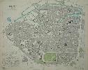
Imprint: London, Baldwin & Craddock, 1837
335 x 390 mm., in early outline colour.
A good detailed plan of the city of Brussels. An early edition and state of this map published by the firm of Baldwin and Craddock. With an inset plan of the surrounding environs there are profiles of notable buildings along the bottom.
Stock number:4664.
|
|
|
Imprint: Leiden, c.1720
255 x 350 mm., in good condition.
A fine birds-eye view of Elbing in present day Poland. The town is shown spanning the Elbing River, bound by its fortifications. The buildings are displayed in great detail. In the foreground are some habitants pausing on the way into town. The view is by Pierre van der Aa (1659-1733), a prolific publisher particularly during the first part of the eighteenth century. By 1682 he was a bookseller and proprietor of an auction house. Amongst these publications is arguably the biggest atlas ever published, the 66 volume 'La Galerie Agreable du Monde'.
Stock number:9611.
|
|
|
Imprint: Leiden, c.1725
290 x 365 mm., in good condition.
A map of Poland by Pierre van der Aa (1659-1733), a prolific publisher particularly during the first part of the eighteenth century. By 1682 he was a bookseller and proprietor of an auction house. Amongst these publications is arguably the biggest atlas ever published, the 66 volume 'La Galerie Agreable du Monde'.
Stock number:9721.
|
|
|
Imprint: Leiden, c.1710
155 x 225 mm., recent outline colour, evenly toned, otherwise in good condition.
Pierre van der Aa (1659-1733) was born in Leiden, the son of a stone cutter or sculptor. By the time he was nine years old he was already apprenticed to a bookseller. By 1682 he was the owner of a bookshop and auction. His output is so large that Koeman was sure that there were works yet to be identified. His printed catalogue of 1729 alludes to the fact that works could be made to order. As with many of his published books the source of the plates contained within is various. This map is likely from the 'Cartes des Itineraires et Voyages Moderne', published in 1707. The map displays the Pacific Ocean with California as an island, but focuses on South East Asia whilst displaying a significant portion of New Holland (Australia). The reference in the title is to Lopo Vaz de Sampaio, the Portuguese Governor of India from 1526-29. He was also captain of Vasco de Gama, the famous explorer. Koeman (1967-70) I pp. 1-30, Aa1 no. 17.
Stock number:9891.
|
|
|
Imprint: Leiden, c.1710
290 x 365 mm., in good condition.
A map centred on the town of Elbing, Poland, now known as Elblag just to the south east of Gdansk. It is by Pierre van der Aa (1659-1733), a prolific publisher particularly during the first part of the eighteenth century. By 1682 he was a bookseller and proprietor of an auction house. Amongst these publications is arguably the biggest atlas ever published, the 66 volume 'La Galerie Agreable du Monde'.
Stock number:9722.
|
|
|
Imprint: Leiden, c.1730
Oblong quarto (190 x 240 mm.), full contemporary calf, joint to upper board weak, spine with raised bands, ornate gilt decorated compartments, gilt title and volume number. With three half titles to each part, part 4 contains 6 maps, 9 town plans and 39 plates; part 5 contains 2 maps and 34 plates; part 6 contains 8 maps, 4 plan and 16 plates, in total 114 plates consisting of 16 maps, 9 plans and 89 plates light water stain affecting about 6 plates, otherwise in good condition.
Pierre van der Aa (1659-1733) was born in Leiden, the son of a stone cutter or sculptor. By the time he was but nine years old he was already apprenticed to a bookseller. By 1682 he was the owner of a bookshop and auction. His output is so large that Koeman was sure that there were works yet to be identified. His printed catalogue of 1729 alludes to the fact that works could be made to order.As with many of his published books the source of the plates contained within is various. This work appears to be on the British Isles and to consist of 6 parts, the last three of which are present here. The 16 maps were those first published in Jan Janssons Atlas Minor of 1648. Here the fundamental difference is the titles are now in French. The 9 plans were all first published in Britannia Magna sive Anglia by Rutger Hermannides. The main difference here is the addition of a key above and some additional toponyms on each plate. The 89 views, largely birds-eye images of country houses, are all from James Beeveralls Les Delices de la Grand Bretagne et LIrlande first published in 1707 and expanded in 1727. Beyond this work we now very little about Beeverall. The illustrations are derived from Loggan, Kip, Slezer and others and are engraved by Jan Goeree (1670-1731). First published in 1707 this second edition is greatly expanded and updated. Despite many images being derived from earlier published works they are by no means slavish copies. Many bear additional decoration of features. Provenance: bookplate of Sir William Maxwell of Monreith pasted inside upper cover. Adams (1967) 20; Brunet (1860-80) 1735; Burden (1992) Berkshire Town Plans pp. 10-11; Deadman & Brooks (2015) pp. 22 & 24; Frostick (2011) no. 15; Koeman (1967-70) I pp. 1-30, II Me 204; Lowndes (1864) 146; Upcott (1968) p. xxiv.
Stock number:9775.
|
|
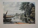
Imprint: London, 1 January 1819
325 x 435 mm., aquatint engraving in superb early wash colour, two small fox marks in lower margin, otherwise in excellent condition with good margins.
This superb aquatint is one of a pair of Richmond printed by Rudolph Ackermann and is taken from near the Duke of Buccleuch property. The engraving is the work of Thomas Sutherland and was from a drawing by John Gendell. Gendall (1790-1865), born near Exeter, displayed early promise as an artist and was sent to Sir John Soane in London. It was through him that he was introduced to Ackermann. No bibliographical reference to be found. Mallalieu (1986).
Stock number:7737.
|
|
Imprint: London, 1766
Edition: First Edition Binding: Hardback Folio (300 x 195 mm.), pp. 4, (243-4) in good condition.
The rare first printing of the repeal of the notorious STAMP ACT of 1765 [5 Geo III Cap.12] which brought such indignation from the American Colonies and ultimately was key to the eventual Declaration of Independence and the American Revolution. The British government had taken on huge debts to finance the French and Indian War and felt that some of the cost should be born by the colonies. The Act placed a tax on all legal and commercial almanacs, cards, dice, newspapers, pamphlets and papers in the American Colonies. It was immediately denounced with the now famous phrase "taxation without representation". The British Government soon realised the error of their ways and in the following session repealed the Act. The political damage was however already done. The ESTC records just three copies. Church 1060; ESTC N56896.
Stock number:8056.
|
|
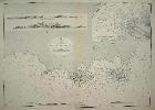
Imprint: London, 1836-[72]
61.5 x 89 cm.Uncoloured chart, with minor creasing along centrefold, and bottom margin.Some age toneing.
Surveyed by Comdr Haines and Assistants. Inset of Aden Anchorage, also 2 insets of the land as seen from the sea.
Stock number:2994.
|
|
|
Imprint: Stockholm, Sammandragen och graverad af E. Akerland pa A Wiborgs forlag, 1818
345 x 420 mm., early wash colour, small foxmark right margin, otherwise in very good condition.
Over the years Australia has been known by different appellations. The most enigmatic of them was Ulimaroa. This map is a later Swedish edition of Daniel Djuberg's original published in Stockholm in 1780. The name was first used by Djurberg (1744-1834) in 1776. A member of the Cosmographical Society in Uppsala he wanted to give the land an indigenous name, instead of the European ones placed on it to date. 'Ulimaroa' is a Maori term originally found in Hawkesworth's edition of Captain James Cook's voyage. Some believe the Maori were actually referring to Grand Terre in New Caledonia. The Austrian mapmaker Franz Anton Schraembl in 1789 published a map using the same name as did Franz Johann Joseph von Reilly.It is highly likely that this map was published in response to Carl Jonas Love Almqvist's novel entitled 'Parjumour Saga ifran Nya Holland' published in Stockholm, 1817. It is the first Swedish novel set in Australia. Erik Akerlund [Akerland] (1754-1835) was a Swedish chartmaker and engraver. He was born in Stockholm and studied engraving there. He joined the globe making firm of Fredrik Akrel where he worked on the series of charts for Johann Nordenankar from 1787. He took over publication of Anders Akerman's 'Atlas Juvenilis' in the early 1800s.Australia is here named as 'Nya Holland eller Ulimoroa'. The map appears to exist in two states, this being the first. A second state has been identified in which 'Forbalttrad 1831' has been added to the title cartouche. Further names have been added to New Zealand and Australia where the Blue Ridge Mountains are present. Ginsberg (2009) pp. 143-4; Tent, Jan & Geraghty, Paul (2012) 'Where in the World is Ulimaroa', in 'Journal of Pacific History' volume 47; Tooley 'One Hundred Foreign Maps of Australia' no. 48, pl. 155; Tooley's 'DIctionary' (1999-2004).
Stock number:9660.
|
|