|
|
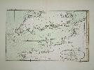
Imprint: Paris, 1764
22 x 35 cms., early wash colour in fine condition
A lovely sea chart from arguably Bellin's greatest atlas, the 'Petit Atlas Maritime'. It shows the English Channel from the Straits of Dover through to the tips of Cornwall and Brittany. Phillips 638 & 3508; Shirley BL M. Bell 5a; Nordenskiold Collection 1 no. 10; Maritime Museum no. 211.
Stock number:4095.
|
|
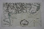
Imprint: Paris, 1764
230 x 360 mm., with early wash colour.
This chart of the approaches to Port au Prince on the island of Hispaniola is from Bellin's greatest atlas, the 'Petit Atlas Maritime'. Phillips 638 & 3508 vol. 1 no. 68; Shirley BL M. Bell 5a; Maritime Museum no. 211 no. 232; Sellers & Van Ee 1890.
Stock number:7428.
|
|
|
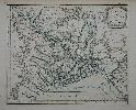
Imprint: Paris, de l’Imprimerie de Didot, 1757
Binding: Hardback Quarto (255 x 195 mm.), full contemporary French mottled calf, gilt ruled, with central gilt Royal arms of Louis XV and gilt arms of the library of Versailles on both boards, rebacked, preserving the original ribbed spine with ornate floral gilt decoration, calf gilt titled label., marbled endpapers. With engraved title page, typographic title page bearing engraved vignette view of Cambridge, pp. (6), 471 with 5 maps in early outline colour and 36 vignette plans, maps and views in total set within the text. Royal Library stamp to title, Ireland inserted, one or two fox marks, otherwise in good condition.
Jacques Bellin (1703-72) was Hydrographer in the French Dépôt de la Marine. With access to the latest navigational reports, he produced a great many maps and charts of excellent quality. The French government commissioned Bellin to translate a large section of Greenville Collins 'Coasting Pilot' for the use of French seamen. The atlas consisted of 19 charts, the text was issued separately in this work entitled 'Essai Géographique sur les Isles Britanniques' in the same year 1757. These uncommon works of the British Isles were issued at the outbreak of the Seven Years War between Britain and France. There are five maps of the British Isles, England, Scotland, Ireland and the Gulf of Edinburgh. The book also contains 36 vignette views, town and harbour plans engraved in remarkably fine detail. The plan of London on page 4 is not listed in Darlington and Howgegos study of London plans. A second edition of the text was issued in Paris by Nyon Libraire, Imprimerie de Moreau in 1759. Provenance: Beeleigh Abbey Books, Catalogue BA56 item 3, June 1995; Rodney Shirley collection. Bonar-Law 'Ireland' no. 87; Cohen-de Ricci p. 129; Cox Travel III p. 92.
Stock number:9906.
|
|
Imprint: Paris, 1764
21.5 x 17cm. In excellent condition, with some wash colour.
Ex 'Petit Atlas Maritime'.
Stock number:3089.
|
|
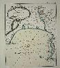
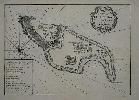
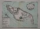
Imprint: Paris, 1764
215 x 180 mm., in early wash colour.
A plan of the harbour of Valinco on the island of Corsica. It is from Jacques Nicolas Bellin's greatest atlas, the 'Petit Atlas Maritime'. Phillips 638 & 3508; Shirley BL M. Bell 5a; Nordenskiold Collection 1 no. 10; Maritime Museum no. 211.
Stock number:4850.
|
|
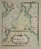
Imprint: Paris, 1764
27 x 33cm.Uncoloured, centrefold, very slight discolouration top margin.
ex'Petit Atlas Maritime'
Stock number:2791.
ISBN:r
|
|
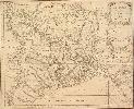
Imprint: Paris, 1764
280 x 335 mm., in early wash colour, in good condition.
An attractive map of Bengal from Jacques Nicolas Bellin's greatest atlas, the 'Petit Atlas Maritime'. This copperplate engraved map shows the whole region in great detail with villages, towns and rivers featured. Dhaka (Decca) in present day Bangladesh is prominently displayed unlike Calcutta (Coolecatte) in West Bengal. The rococo-style title cartouche bears a distance scale. Phillips 638 & 3508; Shirley BL M. Bell 5a; Nordenskiold Collection 1 no. 10; Maritime Museum no. 211.
Stock number:7411.
|
|
Imprint: Paris, c.1760
205 x 280 mm., in good condition.
The Island of Goree is a small island of just 45 acres (0.2 sq. km.) located only 2 km at sea from the main harbour of Dakar, Senegal. It was first occupied by the Portuguese c.1450 as a post to enable further southward exploration down the coast of Africa. In turn it became a Dutch, French and English possession. From 'Histoire Générale des Voyages, ou Nouvelle Collection de Toutes les Relations de Voyages par Mer et par Terre ...' first issued in 1745 followed by a total of twenty volumes.
Stock number:7408.
|
|
Imprint: Paris, c.1760
205 x 360 mm., folding as issued, in good condition.
The Island of Goree is a small island of just 45 acres (0.2 sq. km.) located only 2 km at sea from the main harbour of Dakar, Senegal. It was first occupied by the Portuguese c.1450 as a post to enable further southward exploration down the coast of Africa. In turn it became a Dutch, French and English possession. From 'Histoire Générale des Voyages, ou Nouvelle Collection de Toutes les Relations de Voyages par Mer et par Terre ...' first issued in 1745 followed by a total of twenty volumes. Engraved by Ambroise Tardieu.
Stock number:7409.
|
|
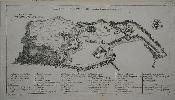
Imprint: Paris, 1764
200 x 265 mm., early wash colour in good condition.
An attractive map of the island of Goree, a small island of just 45 acres (0.2 sq. km.) located only 2 km at sea from the main harbour of Dakar, Senegal. It was first occupied by the Portuguese c.1450 as a post to enable further southward exploration down the coast of Africa. In turn it became a Dutch, French and English possession. It is from Jacques Nicolas Bellin's greatest atlas, the 'Petit Atlas Maritime'. This copperplate engraved chart shows the whole island in detail. The rococo-style title cartouche bears a distance scale. Phillips 638 & 3508; Shirley BL M. Bell 5a; Nordenskiold Collection 1 no. 10; Maritime Museum no. 211.
Stock number:7410.
|
|