Item details: Carte des Gouvernements de Dauphine et de Provence
£ 75.00
BONNE, Rigobert
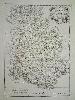
Carte des Gouvernements de Dauphine et de Provence
Imprint: Paris, 1771
410 x 290 mm., in early outline colour, in good condition.
From Rigobert Bonne's 'Atlas Moderne' first published in 1762 by Jean Lattre with maps from various cartographers. Bonne was an engineer, mathematician and cartographer. He succeeded Bellin as the hydrographer at the Depot de la Marine. Jean Lattre was the publisher of this edition, he may also have been this maps engraver. The map covers the southern French provinces of Dauphine and Provence. Shirley BL T.Bonn 1a.