365 x 250 mm., in excellent condition, a very fresh example with a superb large watermark.
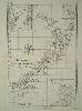
A fabulous example of an early map of New Zealand as newly charted by Captain James Cook and first published in 1773. This map by Rigobert Bonne (1727-95) is from the ‘Atlas Encyclopédique’ but not the usual Paris edition engraved by Gaspard Andre. This is the rarer map engraved by Pietro Scattaglia (c.1739-1810) who is described in Tooley’s ‘Dictionary of Mapmakers’ as an engraver in Venice. It also states that he engraved plates for the similarly entitled atlas published in Padua, 1789. Bonne was an engineer, mathematician and cartographer. He succeeded Bellin as the hydrographer at the Depot de la Marine. With insets of places noted during the voyage: Coromandel Peninsula, Cook Strait, Bay of Islands and Tolaga Bay. Phillips (1909-) 666; refer Shirley (2004) T.Bonn 6a.