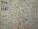
Item details: An Accurate Map of the County of Worcester, Divided into its Hundreds
£ 185.00
BOWEN, Emanuel & KITCHIN, Thomas
An Accurate Map of the County of Worcester, Divided into its Hundreds
Imprint: London, Robert Sayer and Carington Bowles, c.1764
530 x 700 mm., in fine early outline colour, lower centrefold split otherwise in good condition.
The maps from Emanuel Bowen and Thomas Kitchins beautiful 'Large English Atlas' were first sold separately and early issues of the work can be found with varying contents. The project began at the hands of the publisher John Hinton before he ran into financial difficulties. They are superb clear and concise engravings. In the history of English county atlases it is hard to think of one with finer quality. Wardington praised the book saying that the size of the plate presented the publishers, the engravers and the printers with as formidable a task as any posed by the finest productions of Louis XIV or XV, the best of the Dutch engravings fifty years earlier, or the Ordnance Survey sheets fifty years later. Hodson 221 provides a thorough account of the complex history of this atlas, which was finally completed and issued with a title-page in c.1762. This example of the map of Worcestershire is in its fourth state of five. Not in Chubb; Hodson 223, p. 127 & p. 137 state g.