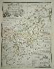
Item details: An Accurate Map of Northampton Shire. Divided into its Hundreds ...
£ 175.00
BOWEN, Emanuel - KITCHIN, Thomas
An Accurate Map of Northampton Shire. Divided into its Hundreds ...
Imprint: London, John Tinney, 1753
70 x 53 cms., early outline colour. In excellent condition with large margins
From 'The Large English Atlas'. Thomas Kitchin was one of the most notable English cartographers of the eighteenth century. He was both an engraver and publisher of considerable reputation who was made Hydrographer to King George III. He worked with many of his contemporaries on various projects. 'The Large English Atlas' was the greatest English county atlas of the eighteenth century and it had a troubled and complicated beginning. The ownership changed many times and the imprints on the maps changed accordingly. This is a fine example of the second although still pre-atlas state by John Tinney with his imprint. Hodson 221 p. 133.