Item details: An Accurate Map of the County of Hereford.
£ 365.00
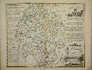
BOWEN, Emanuel.
An Accurate Map of the County of Hereford.
Imprint: London, c.1764. Edition:
First Edition
42 x 51 cms., in early outline colour. A little foxing confined to the lower right corner in the margin only.
Following the success of the earlier published 'Large English Atlas', Bowen and Kitchin undertook a smaller version entitled the 'Royal English Atlas'. It was not a commercial success and as such is much rarer than its predecessor. Indeed the first edition is only known in 6 examples. The imprint below the map indicates that this map is a first state example as only issued in the first edition. It is a wonderful collection of cartographers of the day including the names of Henry Overton, John Bowles, Carington Bowles, John Ryall, Robert Sayer and Thomas Kitchin. Provenance ex Phillips auction 20 September 1984 lot 408. Hodson 233 p. 23 state 1; Shirley BL T.Bow-4a.